What are the best historical sites to visit in and around Manchester?
Historical Manchester is a landscape where centuries of history sit side by side, and one of the best ways to experience it is on foot.
In the heart of the bustling city centre, Manchester boasts Roman remains and layers of industrial history. But if you look beyond the centre, the history of the area becomes even more varied. You’ll find relics of early settlements, hints of fortified outposts, and the remains of once‑powerful halls and estates.
While venturing to historical locations, you can explore dramatic viewpoints, sweeping moorland, and quiet river valleys where engineering marvels and long‑forgotten defences still leave their mark. High on the hills, remnants of ancient strongholds offer panoramic views, while deep in wooded valleys, traces of early industry reveal how the region once powered Britain’s progress.
Whether you’re exploring rural paths or urban routes, walking through Manchester and its surrounds connects you to a timeline stretching from Roman occupation to industrial innovation.
If you’re interested in more historic locations to visit around Britain, or just have an interest in history in general, take a look at all our historic articles. From Roman sites to visit and how to spot history on a map, to the history of place names and fossil hunting, we have plenty of information for both outdoors and history-lovers.
Where can you experience heritage sites in historical Manchester on foot?
Manchester City Centre

- Age: Varied, but nearly 2000 years old in its origins
- Nearest tram stop: St Peter’s Square
- OS Explorer map: Explorer 277 – OS Map of Manchester & Salford
A walk through the heart of historical Manchester offers one of the best ways to explore its layered past. With centuries of political, religious, and architectural history, it’s all within easy reach on foot. There’s truly no better place than the city’s centre for a historical walk, where medieval structures sit beside civic landmarks tied to defining national events.
Highlights include St Peter’s Square, the site of the Peterloo Massacre of 1819. Here, tens of thousands gathered to demand political reform before being violently dispersed in an event now recognised as a pivotal moment in Britain’s democratic history. The square is a key stop on any historical route, offering a powerful reminder of the city’s radical roots.
A short walk from the square leads to Hanging Bridge, one of the few surviving medieval structures in the centre. Once part of Manchester’s defensive network, it stands today near the cathedral as a tangible link to the city’s early urban fabric.
From here, you can continue toward Shambles Square, home to historic timber‑framed buildings relocated and preserved after the 1996 bombing. The nearby Manchester Cathedral, with origins stretching back to the medieval collegiate church, enriches any walk with its architectural heritage and long-standing religious significance.
The combination of these locations form a compact, walkable circuit that showcases the depth and diversity of historical Manchester, allowing you to experience centuries of history in just a short stroll.
Did you know?
Manchester was the world’s first industrial city. During the 19th century, Manchester expanded rapidly thanks to the cotton industry and large-scale mill development.
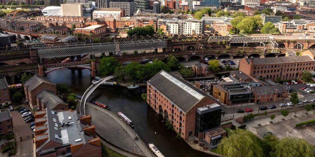
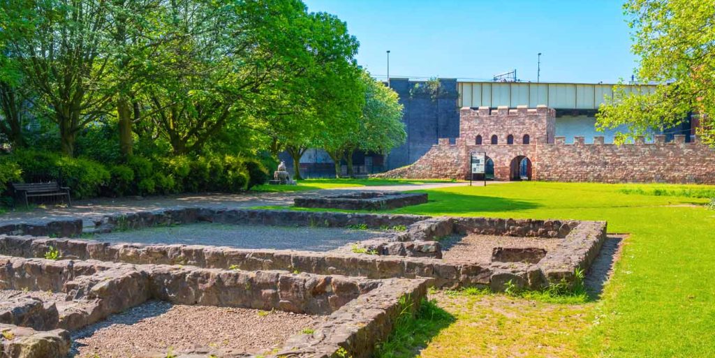
Mamucium Roman Fort
- Age: Almost 2000 years old – AD 78–79
- Nearest tram stop: Deansgate-Castlefield
- OS Explorer map: Explorer 277 – OS Map of Manchester & Salford
Set within Manchester’s historic Castlefield district, Mamucium Roman Fort was established under General Agricola on a sandstone bluff overlooking the junction of the Rivers Irwell and Medlock. Its position allowed Roman forces to control key roads linking major settlements such as Chester, York, and Ribchester, making it a strategically significant military base in Roman Britain.
The fort went through several construction phases. It was initially built from turf and timber, and later expanded and was partially rebuilt in stone. At this time, it was accompanied by a sizeable civilian settlement (known as a vicus) that housed merchants, craftsmen, and soldiers’ families. Today, you can see reconstructed sections of the gatehouse, defensive walls, granaries, and foundations that offer a tangible sense of the fort’s scale and layout.
During your visit, you can wander through the Castlefield Urban Heritage Park, where the fort sits among canals, cobbled paths, and preserved industrial buildings. Close to the fort is the Castlefield Viaduct, which is perfect for a slow, easy walk. This 300m long viaduct was built in 1893, but has recently been converted into an urban park, which is ideal addition to a historical city-centre stroll.
Did you know?
The name “Manchester” derives from a Brittonic word meaning ‘breast‑shaped hill’. It likely came from mamm- (“breast,” referring to a local hill), which was later Latinised as Mamucium/Mancunio, with -chester from Old English, for a Roman fort.
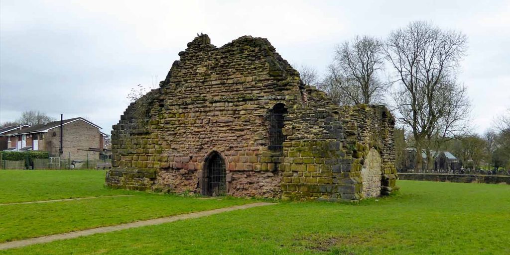
Radcliffe Tower
- Age: Over 600 years old – 1403
- Nearest train station: Radcliffe
- OS Explorer map: Explorer 277 – OS Map of Manchester & Salford
Just outside of historical Manchester in Radcliffe, standing as the last surviving part of a medieval manor house, Radcliffe Tower dates back to a major rebuild of the previous manor house on the site in 1403.
The tower formed part of a larger complex that originally included a stone‑built hall and additional wings. Although most of the manor was demolished in the 19th century, the remaining tower still rises around six metres high. It is a Grade I listed building and a Scheduled Monument, reflecting its national historical significance.
Exploring the site on foot is straightforward, as the tower sits beside open green spaces such as Close Park. Here, you can wander the riverside landscape and view the tower within its wider medieval setting. Its proximity to the River Irwell, which once protected the manor on three sides, is still evident from the surrounding terrain. You can also follow local paths linking the area to other historic sites, such as the remains of Bury Castle located several kilometres to the north, making it easy to incorporate the tower into a broader heritage walk through Radcliffe.
Did you know?
Manchester played a major role in the women’s suffrage movement, when, in 1903, Emmeline Pankhurst founded the Women’s Social and Political Union in the city.

EXPLORE THE
OS Shop
We are with you every step of the way. Shop our trusted walking and hiking maps and guidebooks so you can explore the outdoors with confidence.
Go to the shopCastleshaw Roman Fort
- Age: Almost 2000 years old – AD 79
- Nearest train station: Greenfield (bus to Diggle)
- OS Explorer map: Explorer OL1 – The Peak District – Dark Peak Area
Built as part of Rome’s northern frontier, Castleshaw Roman Fort once guarded the important Roman road linking Chester (Deva Victrix) and York (Eboracum).
Initially constructed from turf and timber, it housed around 500 soldiers before being abandoned in the AD 90s. It was later replaced by a smaller fortlet around AD 105 when a civilian settlement eventually grew up around it. It survived a number of years before the complex was deserted in the AD 120s.
Today, the remains sit on a natural terrace overlooking the Castleshaw Valley, offering expansive views along the route the Romans once monitored. The fort, fortlet, and associated civilian remains are protected as a Scheduled Monument due to their national archaeological importance.
Exploring the site on foot is one of the best ways to understand its role in the landscape. Countless rights of way weave through the valley and around the earthworks, allowing you to follow the outlines of the fort, the smaller fortlet,and the civilian settlement.
The location lies directly along the line of the historic Roman road over Standedge, making it part of a broader walking corridor that also links to the sites of other Roman installations to the east and west. The exposed hillside setting and long‑distance views create a rewarding walking experience that blends archaeology with the Pennine landscape.
Did you know?
Manchester’s medieval town held its first fair in 1223. This was one of the biggest commercial privileges a settlement could receive, attracting traders from across Lancashire.
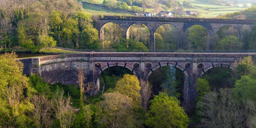
Marple Aqueduct
- Age: Over 200 years old – 1800
- Nearest train station: Marple
- OS Explorer map: Explorer OL1 – The Peak District – Dark Peak Area or Explorer 268 – Wilmslow, Macclesfield & Congleton
Rising dramatically above the River Goyt, the Marple Aqueduct is the tallest canal aqueduct in England, carrying the lower level of the Peak Forest Canal across the valley.
Completed in 1800 after work began in 1795, and designed by engineer Benjamin Outram, the 30‑metre‑high (98‑foot) structure is a Grade I listed monument and Scheduled Ancient Monument. Over the centuries it has undergone repairs, most notably after leaks caused structural damage in the 19th and 20th centuries, while more recent conservation efforts have included repointing stonework, clearing vegetation, and adding safer parapets.
Exploring the aqueduct on foot is one of the best ways to appreciate its scale and impressive construction. A short towpath walk from Marple leads directly to the structure. There are plenty of nearby routes that can take you to further heritage sites such as Marple Locks, a steep flight of sixteen canal locks, and historic lime kilns.
The adjacent woodland, river views, and proximity to the neighbouring railway viaduct create a varied walking experience that blends engineering history with scenic countryside. If you’re looking for a longer walk, you can also explore nearby stretches of the Peak Forest Canal, offering an easy way to explore more of Marple’s industrial and natural heritage.
Did you know?
Ernest Rutherford split the atom in Manchester in 1917.
Watch Hill Castle
- Age: About 900 years – late 1100s
- Nearest train station/tram stop: Altrincham (bus to Bowden)
- OS Explorer map: Explorer 268 – Wilmslow, Macclesfield & Congleton
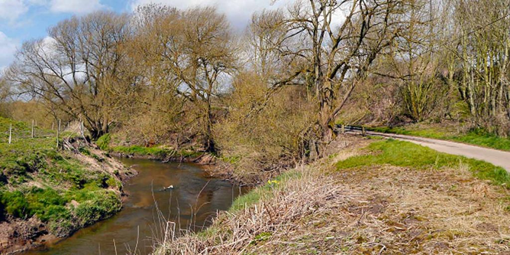
Set on a naturally defensible triangular promontory above the River Bollin, the medieval motte‑and‑bailey castle of Watch Hill likely dates from the period between the Norman Conquest and the 13th century.
Archaeological evidence suggests construction in the late 12th century, and the site is believed to have belonged to the de Mascy family, whose barony dominated the surrounding area. The motte rises about 6 metres high, with a base roughly 40 metres wide, and is encircled by a ditch up to 5 metres wide. Although only earthworks remain, they show the distinctive arrangement of motte and bailey, marking it as one of the oldest and most important archaeological sites in Trafford.
Visiting the site on foot offers a chance to explore not only the castle remains but also the wider landscape that once gave it strategic value. Footpaths such as those along the Bollin Valley Way provide access through riverside woodland and fields, with routes passing close to the motte and continuing toward nearby countryside landmarks.
You can incorporate the castle into longer circular routes around Dunham Massey, where historic estates, wooded ravines, and riverside crossings reflect the same terrain that once made the location defensible. The combination of earthwork archaeology and scenic valley walking makes the site a rewarding stop for anyone exploring the heritage of the area.
Did you know?
UNESCO designated Manchester a City of Literature in 2017.
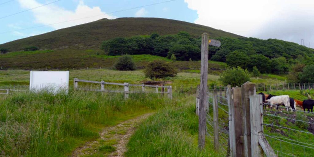
Buckton Castle
- Age: Around 800 to 900 years old – 1100s
- Nearest train station: Mossley Rail
- OS Explorer map: Explorer OL1 – The Peak District – Dark Peak Area
Perched on Buckton Hill in Stalybridge, the medieval Buckton Castle is one of the earliest stone fortifications in North West England.
Built in the 12th century and surrounded by a substantial stone curtain wall, with a ditch up to 10 metres wide and 6 metres deep, it appears to have been constructed as a defensive stronghold within the medieval manor of Tintwistle. Archaeological evidence suggests the castle may never have been fully completed and was already derelict by 1360. Only buried and earthwork remains survive today, now protected as a Scheduled Ancient Monument.
Reaching the site on foot offers an atmospheric walk across open moorland, with trails climbing Buckton Moor and providing sweeping views across the Tame Valley and surrounding hills. You can follow established footpaths from nearby Carrbrook or Stalybridge, linking the castle with other moorland features, including former quarries and long‑distance routes that cross the ridge.
Did you know?
The Old Wellington Inn (1552) is one of Manchester’s oldest surviving buildings
EXPLORE THE
OS Shop
We are with you every step of the way. Shop our trusted walking and hiking maps and guidebooks so you can explore the outdoors with confidence.
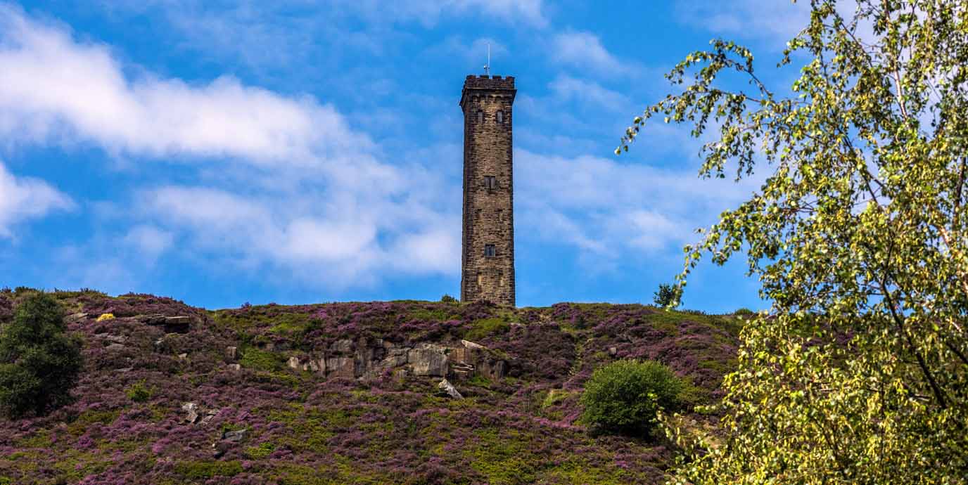
Go to the shopPeel Tower

- Age: Over 170 years old – 1852
- Nearest tram stop: Bury (bus to Holcombe)
- OS Explorer map: Explorer 277 – OS Map of Manchester & Salford
Standing high on the moorland ridge above the village of Holcombe, Peel Tower rises 128 feet (39 metres). It was completed in 1852 as a memorial to Sir Robert Peel, founder of the modern police force and former Prime Minister.
It occupies a prominent position on Holcombe Moor, making it visible for miles across Greater Manchester. Constructed from locally quarried gritstone, the monument has a crenelated base and upper tower. It was opened only two years after Peel’s death following a public fundraising campaign. You can enter the tower on selected days when the flag is flown, and climb to a viewing platform overlooking the West Pennine Moors and surrounding landscape.
Reaching the tower on foot is one of the most popular walks in the region. A well‑established route begins at Lumb Carr Road and ascends Holcombe Hill via cobbled and moorland paths, offering panoramic views over Manchester, the Pennines and, on clear days, even North Wales. The area around the tower connects easily to other local walking routes across Holcombe Moor and the Stubbins Estate, allowing walkers to extend their journey into wider moorland trails.
You can also explore nearby historic points of interest, such as old farmsteads, former industrial sites and long‑used hill paths. The combination of open moorland, atmospheric views and heritage landmarks makes the walk one of the best-known outdoor experiences in Bury and the West Pennine Moors
Did you know?
A devastating plague hit Manchester in 1603, with the town losing almost a quarter of its population.
Quarry Bank
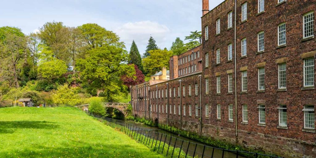
- Age: Almost 300 years old – 1748
- Nearest train station: Styal
- OS Explorer map: Explorer 268 – Wilmslow, Macclesfield & Congleton
Set in the wooded valley of the River Bollin near Styal, the well-preserved 18th‑century cotton mill of Quarry Bank offers one of the most complete examples of an Industrial Revolution factory community in Britain.
Built in 1784 by Samuel Greg, the mill combined water power from the Bollin with early steam technology and grew into one of the largest cotton‑spinning operations of its era. It is now a Grade II listed site, managed by the National Trust (and as such requires a fee to visit), and includes the mill itself, the Apprentice House where child workers lived, and the workers’ village of Styal. Together, they form what the Council of Europe has called “the most complete and least altered factory colony of the Industrial Revolution,” highlighting both its national and international importance.
Exploring the area on foot reveals how industry and landscape shaped each other. Riverside trails follow the Bollin past historic weirs, woodland slopes, and remnants of the mill’s water‑power systems, while longer routes extend into the wider Styal Estate of meadows and woods. You can also walk to features such the restored gardens, and the mill workers’ cottages, all connected by well‑maintained paths. These walks offer insight into both the working lives of the mill community and the dramatic contrasts between the tranquil natural surroundings and the intense industrial activity that once defined the valley.
Did you know?
The Nico Ditch, dating to around 870 is one of Manchester’s oldest surviving earthworks. It likely served as a defensive boundary or a territorial divider.
Bury Castle
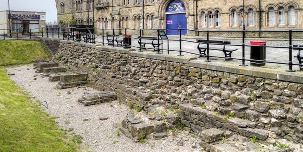
- Age: Over 550 years old – 1469
- Nearest tram stop: Bury
- OS Explorer map: Explorer 277 – OS Map of Manchester & Salford
Set on elevated ground that would have once overlooked the River Irwell, the fortified medieval manor house of Bury Castle was built in 1469 by Sir Thomas Pilkington.
The site originally featured a substantial tower house, stone curtain walls, and a wide moat lined with buttressed masonry. Following Pilkington’s support for the Yorkist cause at Bosworth in 1485, the manor was confiscated by Henry VII and the fortifications were deliberately destroyed. Over the centuries the remains were gradually dismantled or buried beneath later development. Today, the exposed medieval foundations survive as a Scheduled Monument in Bury’s town centre.
Exploring the site on foot is straightforward, as the remains form part of Castle Square in central Bury, adjacent to the parish church and near modern civic buildings. You can trace the outline of the former moat and tower house marked out in the pavement, while interpretive displays and the nearby Bury Art Museum, which holds artefacts recovered during excavations, help contextualise the castle’s history. The location also links easily into wider town‑centre walking routes, allowing visitors to combine the castle with other heritage stops, riverbank paths, and nearby archaeological sites such as the aforementioned Radcliffe Tower a few kilometres to the south.
Did you know?
The population of medieval Manchester was only around 2,500. Although small by modern standards, this size made it a medium-sized medieval town for the region.

Looking for more walking opportunities around Manchester?
Take a look at some of our guides for walking in and around Manchester that might spark interest.
If you’re up for a bigger adventure, one a little further afield, don’t forget that Manchester has the Peak District on its doorstep.