Northumberland is a special place with a variety of landscapes from beautiful beaches to mountainous regions such as the Cheviots. It has it all. For anyone visiting the area, Alnwick makes a great base. It’s well known for its castle and stunning gardens which are not only steeped in history and heritage but are also famous for many appearances in the Harry Potter films. There’s definitely a sense of magic here.
NU 085 097
Nearby is Thrunton woods with many walks to do. I wanted to discover my own adventure so I used Ordnance Survey’s OS Maps to help me plan my day out. One of the greatest features of OS Maps is the detail you get with the Landranger and Explorer mapping. They allowed me to plot a route with precision and confidence. I also found a lovely place to relax after the walk with a drink. I exported the route and saved it to my smart phone. I also printed out the route, took a compass and a power bank.
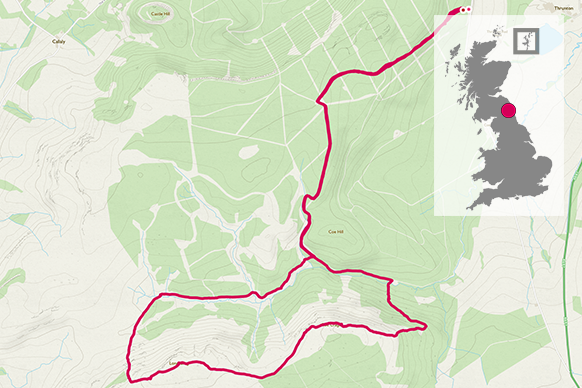
This is a circular route that starts and ends in the car park at the entrance to Thrunton Woods. The start of the walk is a 10 minute drive outside of Alnwick. Thrunton Woods is really accessible with wide tracks that run through the Trees. This route adds some diversity by cutting up through the trees and following a stunning climb to the top. In a short space of time and a little effort you are rewarded with a view which feels like you’re at the top of the world.
I always take kit with me. Waterproof jacket and trousers, a warm base layer (fleece) and a set of hat and gloves. The weather doesn’t care about you so its OK to be prepared. Remember to take water and keep hydrated.
The starting point is from the car park. It can hold quite a number of vehicles too so you shouldn’t go wanting. One other thing, its free so no need to fumble around for coins. The entrance to the walk starts at the North end of the car park. There are a number of paths that tempt you off course when you begin. Ignore the one on the right and carry on up. You’ll then see a path to the left, ignore and keep going. Shortly after, another path on your right climbs up. Ignore that one too. A few hundred yards and you’ll come to a T-junction at the top. Take a left and follow the trail down for a few kilometres.


4.0 km NU 079 075
As you descend, winding down the hill, you’ll see the imposing ridge on your right. Carry on and you’ll come to a small stream with a single foot bridge on your right. Cross the bridge and begin to head forwards and upwards through the trees. After a short climb you’ll join a path. This will carry you up and to the left. Catch your breath halfway up to enjoy the awesome view of the woods down below. Once you’ve taken in the view and captured a few photos, carry on with the steady climb. This is a single track path that takes you up onto the ridge and carries you along. Keep going until you reach the top.


6.5 km NU 069 069
Once you reach the top you’ll notice an Ordnance Survey triangulation point (those large concrete slabs for surveying). Carry on and you’ll start to descend. Be careful of loose rocks. We found the path reasonably friendly even in snow and ice. When you reach the bottom you’ll find a small stream to step over. Once you cross, take the path to the right and follow until you rejoin onto the path you came from. Re-trace your steps back up to the T-Junction then down to the car park. Head back into Alnwick for refreshments.


One of the other great features with OS Maps is the collection of places that you can discover.
Alnwick is host to a beautiful and magical treehouse set in the historic Alnwick garden which serve food and drinks. We visited and reflected on our adventure with some coffee, hot chocolate and cake.
Walking is many things for us. It lets us escape the work and pressures of life and connect with nature. We chat about life and our family, we laugh and joke with each other, we always feel closer and healthier after a great day out walking, minus the cake. Its definitely a lifestyle choice you’ll either agree with or come to love.
12.2 km NU 062 069
12.2 km / 8 miles