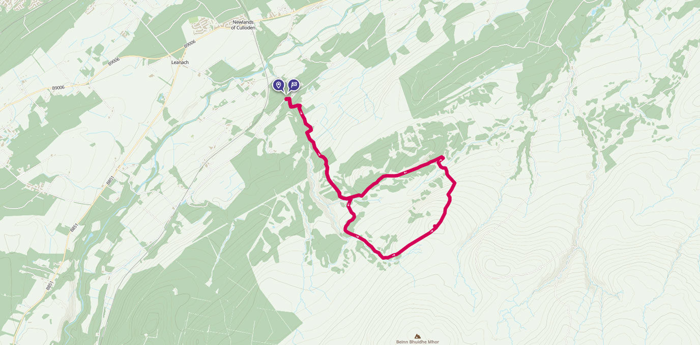
Just south-east of Inverness is a hill known as Beinn Bhuidhe Bheag. At 462m, this 10km route can be done in a morning or afternoon and gives great views over the Moray Firth and Kessock Bridge.
We tried this route while on a short visit to Inverness where we had a spare afternoon. Despite typical Scottish Highlands summer weather (drizzle, but warm drizzle!), this made a pleasant walk. This route is steep and rocky underfoot in places, so is easy to moderate difficulty. The path keeps you out of the boggy surroundings, so at you will keep your feet dry, and is easy to follow. The peak is fairly exposed compared to the start point near the bottom of the valley; despite the relatively small altitude change there can be a distinct drop in temperature, so carry an extra layer.
NH 767 444
If you are coming from the south, take the Daviot turning, or from the north or Inverness drive past the Culloden battlefield. Be careful on the single-track road as there are a lot of blind corners! There’s a convenient lay-by with space for four or five cars right at the start point.
From the lay-by, cross the road and head up the un-named farm track to the south. As you pass the farm buildings, take the path ahead and slightly right to follow the treeline. You’ll pass through a gate and then through a section of the woods. Carry on until you reach a point where the path splits.

NH 776 428
You can do the loop section in either direction – we chose the right-hand path to head south. Follow the path up the hill, and pass a small refuge hut – this was closed and locked and is not marked as a bothy, so I assume it must be used by the landowner. It does provide a little shelter on this otherwise very open section.
Carry on past the hut and then keep left when the path forks at NH 781 420. If you wanted a longer route, and to bag the trig point at the top of Beinn Bhuidhe Mhor (548m), bear right, although this path is a dead end. Continue on the left route to head up to Beinn Bhuidhe Bheag and carry on the path until you reach the cairn at the peak.
Take a moment to enjoy the views over Inverness, the Moray Firth and Kessock Bridge.


NH 790 423
From the peak head east down the slope, staying on the main path. There are a couple of steeper downhill slopes with some loose rock, so pick your footing carefully. Cross the bottom of the valley and look for the deep pool at NH 791 433, then take the left hand path at the T-junction.
Follow this path back along the relatively level side of the valley to rejoin the path you came in on. Head right and follow the route back down to return to the start point.

NH 767 444
10 km / 6 mi