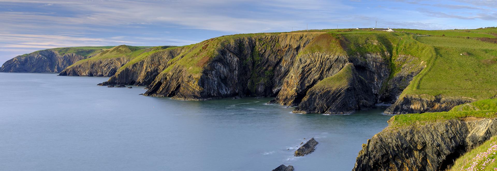
Revealing incredible beauty on every side, the Pembrokeshire Coastal Path is a national trail which undulates gently for 186 miles between Amroth and St Dogmaels. You’d be much mistaken for thinking this is just any coastal path – a walk along this route offers some views which are nothing short of breath-taking.
Find out more about Pembrokeshire National Park
Here are ten of our favourites walks on the Pembrokeshire Coastline.
1. Freshwater West

Near Castlemartin on the most southerly point of the trail is Freshwater West, a beach which is known as a surfer’s paradise. It’s also the site of the Shell Cottage (though it’s sadly been removed) which was constructed for Harry Potter and the Deathly Hallows.
EXPLORE FRESHWATER WEST
OS PAPER MAP: EXPLORER OL36
2. Caer Bwdy Bay

South of St Davids, these azure blue waters belong to the pebble beach at Caer Bwdy Bay. At low tide, a sandy stretch is exposed. Situated at the end of the valley, the small beach is perfect if you want to get away from it all – there’s no parking and no facilities, which means it doesn’t ever get too crowded.
EXPLORE CAER BWDY BAY
OS PAPER MAP: EXPLORER OL35
3. Strumble Head Lighthouse

Located in the Pencaer Peninsula, a rocky headland on the northern portion of the trail near Fishguard, this beautiful spot comes to life at sunset. The lighthouse itself is fully automated, so there’s no access to it. Still, it makes for a great view.
EXPLORE STRUMBLE HEAD
OS PAPER MAP: EXPLORER OL35
4. Skomer Island

The inviting turquoise waters belie the fact that you’re not looking at an atoll in the Pacific Ocean, but at Skomer Island – which can be seen from the Coastal Path at Marloes and St Brides. Famed for its wildlife, you could spot puffins, seals or even dolphins. It’s possible to stay on the island or take a boat trip.
EXPLORE SKOMER ISLAND
OS PAPER MAP: EXPLORER OL36
5. St Govan’s Chapel

Nestled along the path between St Govan’s Head and Huntsman’s Leap near Bosherston is this fantastic building. Dating from the 6th Century, it was the home of Govan, a hermit, who was hiding from pirates. Reaching it requires descending some steep steps, but legend has it the number of steps you count down and up are never the same.
EXPLORE ST GOVAN’S HEAD
OS PAPER MAP: EXPLORER OL36
6. Marloes Sands

A sunset walk across the sands is most romantic and not an activity we Brits usually think of undertaking on home turf. Unless, that is, you’re lucky enough to be near one of the Pembrokeshire Coast beaches – like this one, Marloes Sands. A mile of golden, curved beach in a fairly remote spot, it was used in the film ‘Snow White and the Huntsman’. Watch the tide times if you’re going to visit.
EXPLORE MARLOES SANDS
OS PAPER MAP: EXPLORER OL36
7. Tenby Harbour

This gloriously pretty, pastel-painted harbour is one of the main attractions on the walking route and if you’re looking for Pembrokeshire Coast Path accommodation, you might want to consider Tenby, with its medieval walls and castle. What’s more, the stunning beach was named the most beautiful in Europe in 2014.
EXPLORE TENBY HARBOUR
OS PAPER MAP: EXPLORER OL36
8. Elegug Stacks

No, this isn’t from Game of Thrones, it’s the Stack Rocks (also known as Elegug Stacks) at Castlemartin. They are jagged limestone shards which have been created by the natural erosion of the rock around them. Striking to look at, the stacks house many seabirds, so don’t forget your binoculars.
EXPLORE ELEGUG STACKS
OS PAPER MAP: EXPLORER OL36
9. Barafundle Bay

Barafundle, a beach in the heart of the Mediterranean…all right, it’s not, but it could be. The Bay, in Stackpole, is among the most photographed points of the Pembrokeshire Coastal Path and for good reason. Don’t you just want to dive in?
EXPLORE BARAFUNDLE BAY
OS PAPER MAP: EXPLORER OL36
10. Green Bridge

This dramatic rocky arch is called the Green Bridge and is a famous landmark. Located near Elegug Stacks, one of the best times to visit is at sunset, where the orange glow magically illuminates the arch. Access is via an army tank range which is sometimes closed, so check before setting out.
EXPLORE GREEN BRIDGE
OS PAPER MAP: EXPLORER OL36
These are our favourite views of the Pembrokeshire Coastal Path – what about yours? Have we missed a location? Let us know what you think.
BEST BEACHES IN PEMBROKESHIRE
PLAN YOUR TRIP WITH OS MAPS
MORE ON THE PEMBROKESHIRE COAST PATH