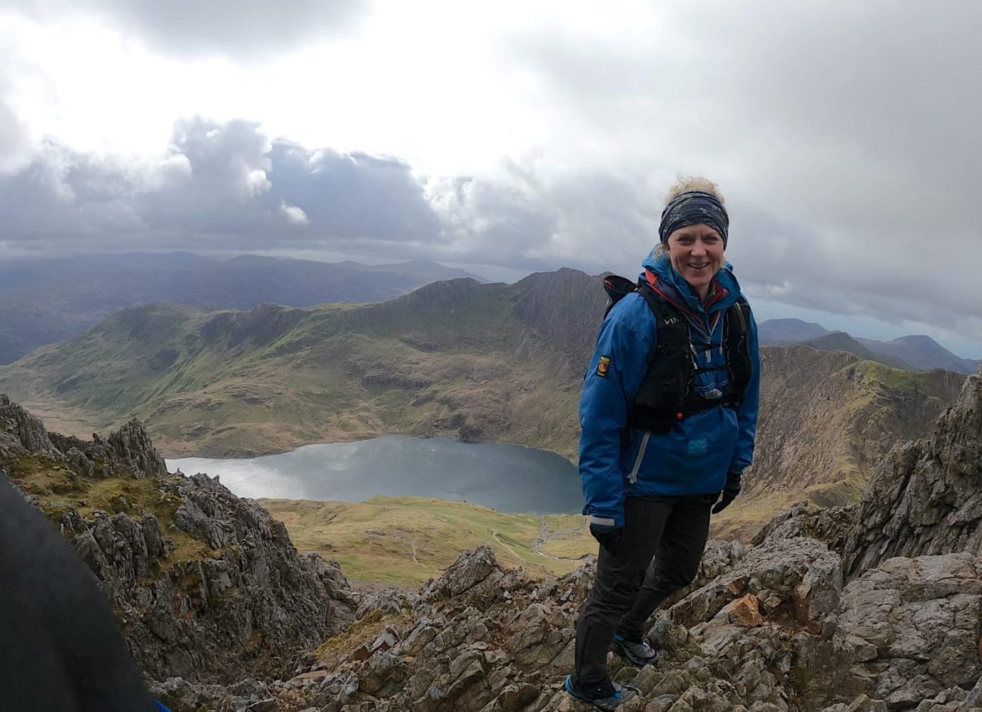
The Best Yr Wyddfa (Snowdon) Routes
There are many routes to the top of Snowdon (in Welsh ‘Yr Wyddfa’) with some big paths that can get crowded and some lesser-trodden trails. Here’s all you need to know about the Yr Wyddfa (Snowdon) routes you can explore on your next trip to Eryri (Snowdonia).
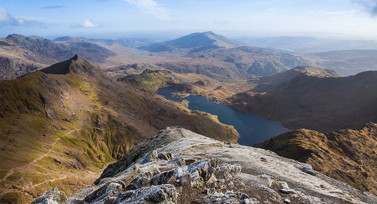
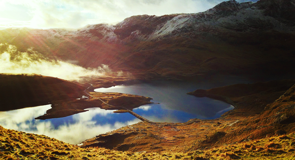
Snowon (Yr Wyddfa) with a dusting of snow
How Many Yr Wyddfa (Snowdon) Routes Are There?
There are 7 main routes up to the summit of Yr Wyddfa. Situated in Eryri, North Wales, the spectacular network of Yr Wyddfa (Snowdon) routes consists of glacial corries, knife-edged aretes and some very big mountains. There are a variety of routes to the summit with different degrees of challenge, but all with tremendous scenery and breath-taking views. The Snowdon Llanberis Path and the Snowdon Ranger Path are the easiest way to the top, with Rhyd-Ddu, the Pyg Track and the Miner’s Track other popular Snowdon (Yr Wyddfa) trails. The Snowdon Horseshoe should only be tackled by experienced walkers with steady nerves as it includes the infamous Crib Goch!
You can pick and choose your ascent and descent, one of the most classic is the route up the Pyg Track and Down the Miner’s track which we describe in detail at the end of this post.

EXPLORE THE
OS Shop
We are with you every step of the way. Shop our trusted walking and hiking maps and guidebooks so you can explore the outdoors with confidence.
Go to the shopShop Eryri OS Maps & Hiking Guidebooks
How Long Does it Take to Climb Yr Wyddfa (Snowdon)?
There are a few routes up to the summit of Yw Wyddfa (Mount Snowdon) of varying distances and difficulties. These routes are between 11km and 14.5km, and can take between 4 to 7 hours depending on your hiking ability and weather.
Yr Wyddfa (Snowdon) Routes Comparison Table with Distance and Ascent
| OS Maps Route Link | Description | Length (km) | Total Ascent (m) | Approx Time |
|---|---|---|---|---|
| Llanberis Path | The most popular and longest route, with a steady climb. Read More | 14.76 | 987 | 6hrs |
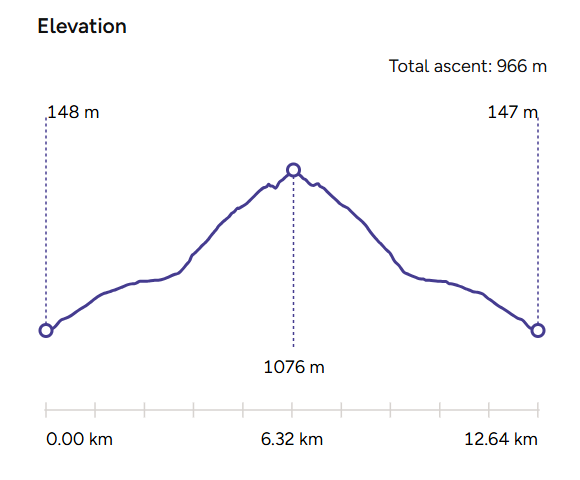
Snowdon Ranger Path | One of the oldest and quieter paths, with scenic views. Read More | 12.7 | 966 | 5hrs 30 min |
| Rhyd-Ddu Path | A quieter route with breathtaking views and a ridge walk. Read More | 13 | 1050 | 5hrs 45 min |
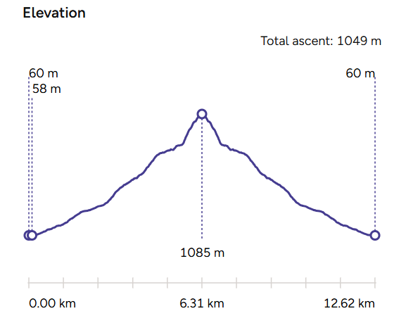
| The Pyg Track | The shortest route with a rugged and challenging path. Read More | 10.8 | 807 | 4hrs 30 min |
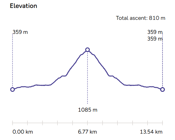
| Miners’ Track | Starts easy, then joins the Pyg Track for a steeper ascent. Read More | 13.5 | 810 | 5hrs |
| The Snowdon Horseshoe | A challenging circular route with scrambles and stunning vistas. Read More | 11.7 | 1176 | 5hrs 30 min |
| The Watkin Path | One of the hardest routes, starting low and featuring steep sections. Read More | 12.6 | 1,050 | 5hrs 30 min |
Follow the links to OS Maps for detailed Snowdon routes, or find the paper Snowdon (Yr Wyddfa) maps for your trip at the end of this article. The time shown doesn’t include stops for food or if you need a rest so remember to factor in plenty of time depending on the fitness level of your group. Read our Hiking for Beginners guide to find out everything you need to know before you attempt any of these Snowdon routes.
Map of Yr Wyddfa (Snowdon) Starting Points

Snowdon (Yr Wyddfa) walking route start points. Click for full size image
Llanberis Path
The most popular route up Snowdon (Yr Wyddfa), the Llanberis Path is the longest, but is a steady slog with only a couple of steeper sections. The path is generally very clear and easy to navigate – in summer there will be a constant stream of walkers to follow. Like all Snowdon (Yr Wyddfa) routes, it should be respected in winter when snow can hide the route, and high winds can make it both much colder and harder work.
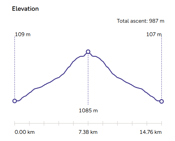
It also gives the option for taking the Snowdon Mountain Railway one or both directions, which is ideal for groups including those unable to make the walk.
Snowdon Ranger Path
The oldest and one of the most amiable ways up Snowdon (Yr Wyddfa) is the Snowdon Ranger Path. Technically it’s on a par with the Snowdon Llanberis Path, yet it’s quieter and scenically far more compelling. It curves around the sheer-sided cirque that lulls the waters of Llyn Du’r Arddu, before joining four other routes for the final march to the top.
Snowdon Ranger Track
Rhyd-Ddu Path
One of the finest walks up Snowdon (Yr Wyddfa); it’s quiet, it’s not too taxing, and the views are breathtaking. This route starts at the village of Rhyd-Ddu, before winding up Snowdon’s western incline to the sharp curve of the Llechog Cliffs and Bwlch Main. This ridge is a treat – narrow enough to be fun (needing just the occasional steadying hand), but wide enough to be a reassuring foothold in the clouds – with big panoramas of the Nantlle Valley and Moel Hebog. Huge views and fun hiking.
The Pyg Track
The Pyg Track is a tough but pretty straightforward hike up Snowdon’s eastern slopes, with occasional gnarlier boulders to make things interesting. Progress is lung- stretching from the start with a stiff haul from the car park, a levelish hiatus, then muscle-burning zigzags to the summit. Fortunately, the views just have to be stopped and gazed at often.

Snowdon Miner’s Track
Miners’ Track
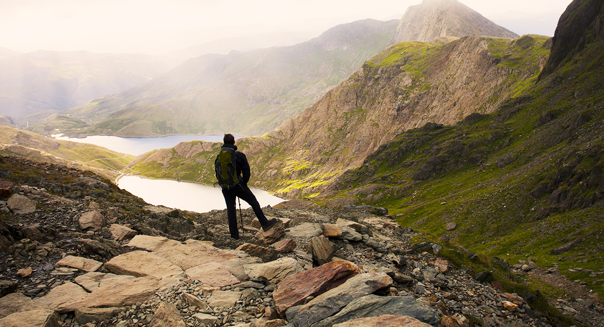
The Miners’ Track starts with a steady clamber to Llyn Llydaw, across the causeway and on to Glaslyn. Look west and you’ll spot the summit crowning a sheer wall of crag, but don’t panic – this route ascends well-built steps to join the Pyg Track, before sweating up those infamous zigzags to the top. Most folk go up the Pyg and down the Miners’.
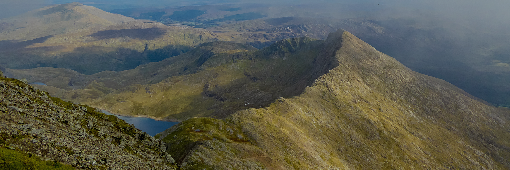
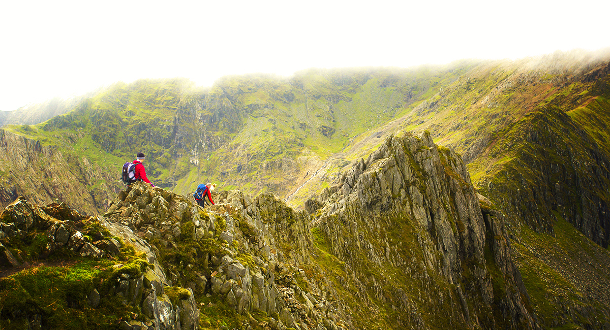
The Snowdon Horseshoe
It’s narrow, high, hands-on and for many the best walk ever, but for some just too scary. It shares its start with the Pyg Track before taking a sharp turn right – vertically – at Bwlch y Moch (Pass of Pigs) to Crib Goch. This boot-width spine of rock is the ultimate test, making the subsequent wide summit of Snowdon (Yr Wyddfa) seem easy. Y Lliwedd adds spice to the horseshoe’s return curve, with a vertigo-inducing view down to Llyn Llydaw, before a relatively easy ‘stroll’ along the Miners’ Track. Best left to very experienced hillwalkers with a head for heights.

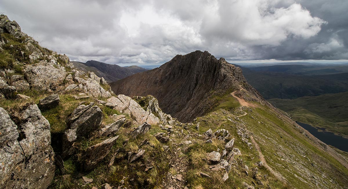
Crib Goch – part of the Snowdon Horseshoe
The Watkin Path
Known as one of the hardest routes to the top, and therefore less travelled. Dangerous loose scree and rocks on the upper stretch, a hard to follow path in places, some scarily steep drops, and tricky footing, all demand extra care especially in bad weather. The route passes an abondoned quarry, Cwn Llan, Bwlch Ciliau below Y Lliwedd going up and the usual descent is via a loop down Allt Maenderyn the Pyg and Miners’ tracks.
The Pyg Track ascent and Miners’ track descent
Is there a better way for a walker to get to grips with Wales’ highest peak than this; the classic circuit using the Pyg Track and Miners’ Track? Probably not. A glorious ascent, full of mountain spectacle, but easy enough for almost any fit walker. But how hard is the Pyg Track?
The walk starts at a height of 359m at the top of Pen-y-Pass. Pass, meaning some of the hard work is done for you, and it’s pretty direct from there. Watch out for the awesome views of Crib Goch and Y Lliwedd, as well as the Irish Sea coast. The descent on the Miners’ Track allows for plenty of adoring backward glances at the magnificent peak you’ve climbed.
Locate the start of the path heading due west from car park (to far right, with Crib Goch in view on the horizon). Follow this path for one mile as it climbs steadily above Llanberis Valley, eventually reaching a col on the skyline, where the path diverges at a post signed ‘Pyg Track’ (ahead) and ‘Crib Goch’ (right).
Snowdon Pyg Track
Follow marker for Pyg Track – under no circumstances follow the Crib Goch sign, it leads to a terrifying edge. The track continues into Snowdon cwm, with Llyn Llydaw below. The track then hugs the flank of Crib Goch, with a fabulous view opening out to Snowdon (Yr Wyddfa), dead ahead. There are some stepped sections and a few tricky rocks along this stretch. Passing above Glaslyn lake, the path steepens and becomes flagged as it climbs to the summit ridge, emerging on the ridge next to a large marker stone. Turn left on the ridge and follow the Snowdon Mountain Railway line to the summit, where you’ll find the new summit station ‘Hafod Eryri’, and eventually the summit itself.
From the summit, descend on the same path as you came up and return to the marker stone at the top of the Pyg Track. Turn right and descend the Pyg Track. At another marker stone, branch right on the path descending directly to the shore of Glaslyn below. This is the Miners’ Track, and despite some maintenance work, parts of it are still a little indistinct. The path gets clearer from Glaslyn onwards; follow it due east and descend to Llyn Llydaw reservoir.
Skirt the edge of the reservoir, passing some abandoned buildings, to reach a causeway across the water. Cross the causeway and continue on the Miners’ Track, taking time to admire view behind of the Snowdon (Yr Wyddfa) Horseshoe. The path weaves around the side of a small hill (separating it from the Pyg Track), and finally returns to the car park.
EXPLORE THE
OS Shop
We are with you every step of the way. Shop our trusted walking and hiking maps and guidebooks so you can explore the outdoors with confidence.
Go to the shopShop Eryri OS Maps & Hiking Guidebooks
See More Eryri National Park (Snowdonia) Articles

Yr Wyddfa (Snowdon): Routes to the top
There are many routes to the top of Snowdon (in Welsh ‘Yr Wyddfa’) with some big paths that can get crowded and some lesser-trodden trails. Here’s all you need to know about the routes up Snowdon.
Best Beginner Hikes in Eryri (Snowdonia)
Beginner hikes in Eryri! Hilary Pullen, North Walian and Editor of Get Outside has picked some great beginner hikes to try in Snowdonia!
Eryri National Park (Snowdonia)
Peaks, paths and lakes for great walks, climbs and fishing.
Buy the Ordnance Survey maps for this area