Shaun the Sheep is the champion of Natural England’s Countryside Code. Shaun shares some of his favourite short walks suitable for the whole family.
Shaun the Sheep’s Countryside Code
Living on Mossy Bottom Farm, Shaun’s connection to the countryside makes him a baa-rilliant and fun ambassador for nature, and he is helping encourage families to enjoy the outdoors respectfully. We’ve plotted Shaun’s favourite short walks in OS Maps to make navigation a breeze.
Follow the Countryside Code on social media or visit the Countryside Code website and see where Shaun’s next outdoor adventure will take him.
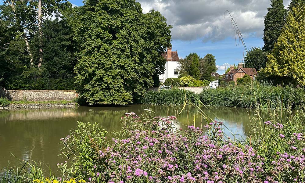
Seven Sister’s Country Park walk
South Downs National Park

Seven Sister’s Country Park walk
Distance: 2.9miles / 4.6 km
Time: 1½ hours
Parking: BN25 4AD Pay and display car parks on both sides of A259 close to Visitor Centre: Riverside and Forest Car Parks
Terrain: Concrete and gravel tracks, beach and, for alternative finish, grassy fields
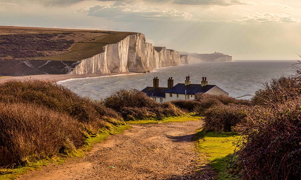
Seven Sister’s Country Park
Named after the famous Seven Sisters chalk cliffs, which form part of the spectacular Sussex coastline between Eastbourne and Seaford, the Country Park is one of the most popular beauty spots in the South Downs National Park. Visitors can walk freely throughout the park, taking in the different habitats, including the meandering river valley, shingle beach and open chalk grassland. A regular bus service between Brighton and Eastbourne stops at the park entrance; a good option, especially at weekends and during the summer when the car parks can get very busy
The Lizard walk
Cornwall
The Lizard walk
Distance: 2.7 miles / 4.3 km
Time: 1¾ hours
Parking: TR12 7NH The Square car park
Terrain: Pavement, lanes, stony tracks and grassy paths
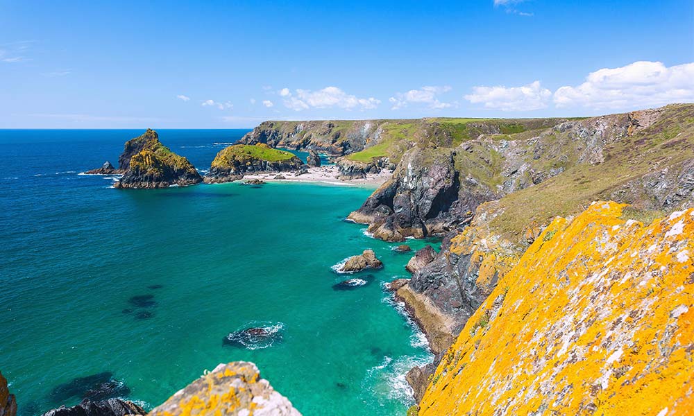
Lizard Point
Its name derived from the Cornish ‘lezou’ meaning simply ‘headland’, the Lizard peninsula has a character all of its own. And the little village of Lizard, near the southern tip, provides a handy starting point for a clifftop adventure. The view from the coastal path at 6 of the sea crashing into the rocks in Housel Cove on a windy day can be wonderfully dramatic. Halfway round you can refresh yourself in a café perched high on Britain’s most southerly point
Buriton walk
South Downs National Park
Buriton walk
Distance: 2.5 miles / 4 km
Time: 1½ hours
Parking: GU31 5RT, Village car park adjoining church and pond.
Terrain: Lanes, woodland and field paths, and South Downs Way lane/track
Buriton village pond
Peacefully situated at the foot of the wooded South Downs escarpment on the eastern edge of Hampshire, the pretty village of Buriton is easily reached from the A3 or the town of Petersfield, 2 miles to the north. The latter has a railway station and bus services to Buriton. Starting from the picturesque pond and Norman church, this short walk takes you up through the interesting Buriton Chalk Pits Local Nature Reserve, along an undulating stretch of the South Downs Way and back downhill through woodland, returning to the village along a field-edge path. There’s a house on the South Downs Way which has been selling delicious homemade flapjacks for year. Don’t forget your 1 for the honestly box.
Straddling the A3 to the south-west of Buriton, Queen Elizabeth Country Park covers some 1,400 acres of open access woodland and downland, including Butser Hill, the highest point on the South Downs. There’s a network of trails, with four long-distance paths running through it: Hangers Way, Shipwrights Way, Staunton Way and South Downs Way. Halls Hill car park, an alternative starting point for this walk and is located at the north-east corner of the country park.
Ravenglass walk
Lake District National Park
Ravenglass walk
Distance: 2.2 miles / 3.5 km
Time: 1¼ hours
Parking: CA18 1SQ, Lake District National Park pay-and-display car park on Croftlands Drive, Ravenglass (not railway car park)
Terrain: Village lane, shore path, beach and good track under trees
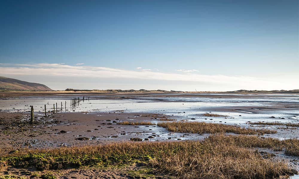
Ravenglass estuary
Did you know the Lake District has a coastline? Not only that, but it also has a pretty little seaside village, called Ravenglass. The Romans knew about it and built a port here. Take a stroll along the England Coast Path to see the remains of the Roman bathhouse and to enjoy the serenity of the village and the estuary.
Ravenglass is the only coastal village within the Lake District National Park. It sits on an estuary where three rivers meet – the Esk, Mitre and Irt. On a clear day, from higher points on this section of the coast, it’s possible to look out across the Irish Sea to the Isle of Man. Please be aware, the 150-yard section of the route beside the River Esk floods at exceptionally high tides.
Bamburgh Castle walk
Northumberland
Bamburgh Castle walk
Distance: 1.5 miles / 2.4 km
Time: 1 hour
Parking: NE69 7BJ Links Road long-stay car park, Bamburgh
Terrain: Pavement through village; sandy trail; surfaced paths
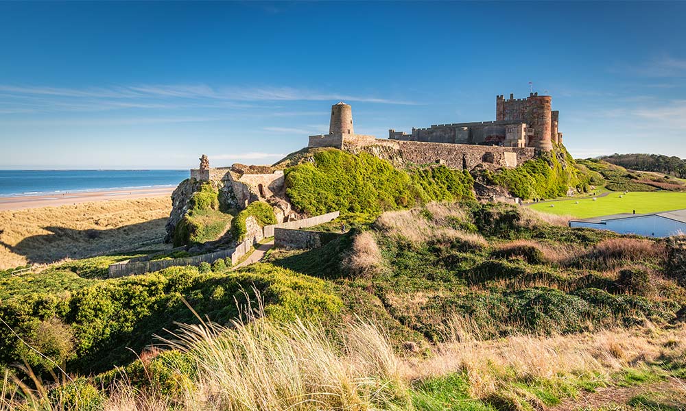
Bamburgh Castle walk
The small village of Bamburgh is dominated by its massive castle, Alnwick, sitting atop a rocky crag. This walk completes a circuit of the imposing complex of buildings, first taking to a sandy trail that looks out beyond wildlife-rich dunes to the Farne Islands. Coming back round the landward side of the fortress, the route crosses Alnwick Castle green and then heads up into the village – to the grave of the 19th-century heroine Grace Darling and a museum dedicated to her memory. Alnwick Castle had a starring role as Hogwarts School of Witchcraft and Wizardry in the films Harry Potter and the Philosopher’s Stone and Harry Potter and the Chamber of Secrets.
Tintagel walk
Cornwall
Tintagel walk
Distance: 1.5 miles / 2.4 km
Time: 1 hour
Parking: PL34 0DD, Old Tintagel Country Club car park, Atlantic Road
Terrain: Lanes and tarmac paths; gravel tracks; grassy paths
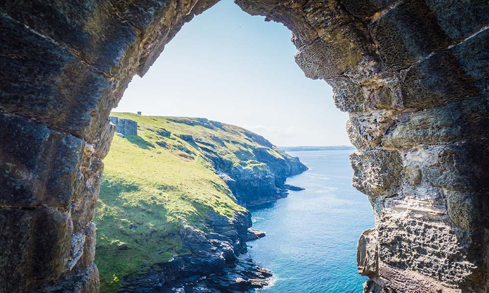
Tintagel walk
Very nearly an island and seemingly intent on breaking off from the mainland altogether, Tintagel Head is one of the most romantic and mystical locations in Britain. This walk heads out from the eponymous village to explore a little of the rugged coastline before arriving at the castle itself. Along the way it takes in Barras Nose, a small headland that provides both the very best views of the castle and a great spot for a picnic.
August 2019 saw the opening of a bridge between the mainland and the castle, finally replacing the narrow natural land-bridge lost sometime in the Middle Ages. Some observers opposed the crossing, calling it a desecration of the historic site. However, the elegant cantilever bridge – designed to evoke Arthur’s sword Excalibur – appears to have few critics today. Rather thrillingly, its two sides don’t quite meet in the middle – there’s a small gap between them.
Pembroke Castle and waterways walk
Pembrokeshire
Pembroke Castle and waterways walk
Distance: 1.7 miles / 2.7 km
Time: 1 hour
Parking: SA71 4EA, Pembroke Castle car park, Common Road
Terrain: Pavements and well-surfaced walkways
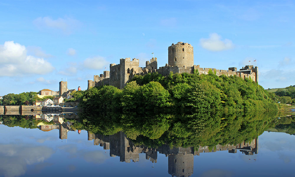
Pembroke Castle
The tiny town of Pembroke is dominated by an imposing medieval castle that towers high above a serene and beautiful waterway. Good paths trace an easy line around the castle and follow the shores of the waterway, and these can be linked to make a lovely walk that’s well surfaced and accessible for all. There’s plenty of wildlife to see despite the more urban environment, and the route can easily be combined with a castle tour and town centre visit to produce a fabulous day out.
This walk visits two of Pembroke’s three waterways: the Castle Pond and the Middle Mill Pond, which is actually the largest of the three. Upstream again lies the Upper Mill Pond, a smaller body of water that’s not accessible by road.
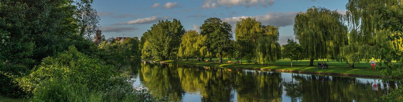
River Thames at Goring walk
The Chilterns
River Thames at Goring walk
Distance: 3 miles / 4.8 km
Time: 1½ hours
Parking: RG8 9HB, Wheel Orchard pay and display car park, Goring
Terrain: Village roads and pavements; rough tracks; riverside paths and meadow. (Thames Path sometimes floods in winter.)
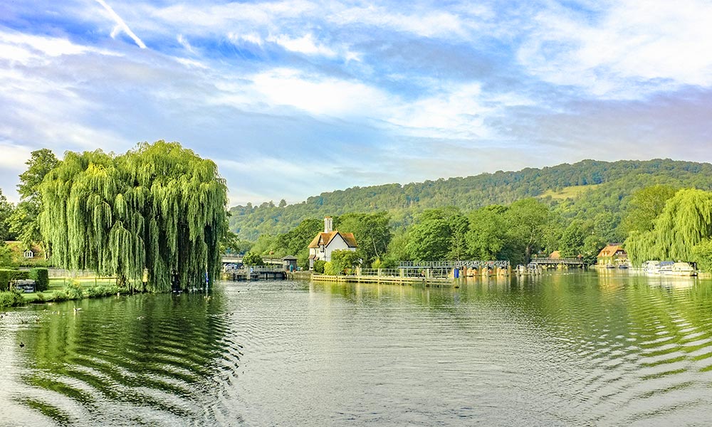
River Thames at Goring walk
Goring is a picturesque village located in one of the loveliest stretches of the Thames Valley – where the rolling Chiltern Hills meet the farmed uplands of the North Wessex Downs. After
leaving the village, this walk follows a series of easy-going tracks out into the pretty countryside. Beyond the tranquil hamlet of Gatehampton Manor, it joins the Thames Path for a relaxing
riverside stroll back to Goring where a choice of pubs and cafés await the tired walker.
Goring lies on the south-western edge of the Chilterns Area of Outstanding Natural Beauty (AONB). Recognised for their exceptional landscapes, there are 46 AONBs in England, Wales and Northern Ireland, each of which receives a degree of statutory protection. The area on the other side of the River Thames lies within the North Wessex Downs AONB.
We love being outside and we all have a job to protect these spaces, so we can all enjoy them for years to come. The Countryside Code helps us do just that. It’s an important tool to help us all feel confident in enjoying time outdoors in a safe and respectful way. So, whether you’re interested in finding a local park near you, trying one of these walks or planning an adventure further afield, be sure to take a look at the Countryside Code before you set off.
These walks are from the Ordnance Survey’s ‘Short Walks Made Easy‘ series. The pocket-sized guidebooks offer leisurely walks between 1 and 5 miles, with simple to follow step-by-step instructions; essential logistical information including accessibility, parking & dog suitability; fascinating local information and nature guides; and stunning photography.