How to measure distance on a map
Measuring distance is a key tool in map reading and is especially useful for hikers and cyclists who want to measure how far they have travelled or how far they wish to go. Learn how to easily measure distance on a map with our quick and simple guide.
Step 1: Find your scale
First of all, you have to know your scale. If you understand the map scale number that’s great, but if you find that tricky you can still measure distances accurately.
At the bottom of each map there’s a scale that indicates the distance on the map. When you measure a distance on the map, just compare it to the scale, and it will instantly tell you the real world distance.

Example of a scale from an OS Explorer 1: 25 000 map
Step 2: Measuring the distance
You can measure straight line distances on a map with a ruler – there’s often one included on the side of your compass. However, if you use the technique above, you can use almost anything – your pencil, fingers or a twig – to get a distance and compare it to the map scale. No maths required!
This does have one big drawback – you can only measure straight lines, which are not that common outside cities. While you could take lots of small measurements and add them up, there’s an easier way using just a bit of plain old string. Try using the lanyard from your compass or a spare shoelace if you don’t have a handy bit of string in your pocket.
Lay the string out along the route. You may need to use some extra fingers to pin it in place. Once you have covered the route, carefully mark the string (or just hold it in the right place) and compare it to your map scale.
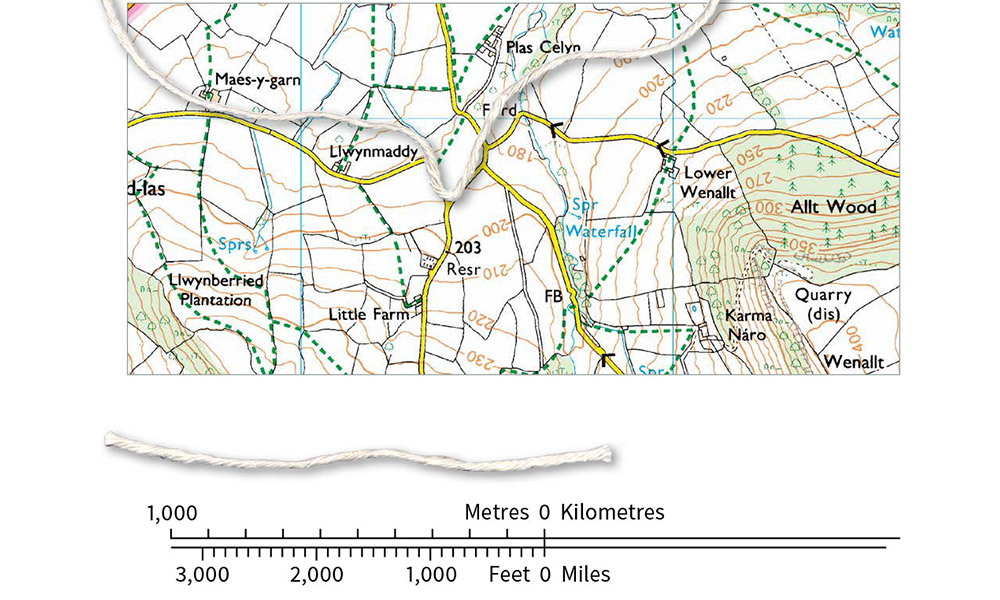
Place the string on your map and then measure the string against the scale
Step 3: Calculating distance from the scale
Sometimes you can’t just compare to a printed map scale. You might be using a map with no printed scale, or you’ve folded your map up into the map case and can’t get to it easily. If you have your handy ruler you can still calculate distance.
Measure your distance using a ruler or string as above. If you used a bit of string, measure the string to get a distance in cm.
Now, you need to multiply that distance by the map scale, and convert that to meters or kilometres.
Examples:
1: 8.5cm measured on a 1: 25 000 OS Explorer map
| Multiply distance by scale 8.5cm x 25,000 = | 212,500 cm |
| Convert to meters 212,500 / 100 = | 2,125 m |
| Convert to km: 2,125 / 1,000 = | 2.125 km |
2: 12.8cm measured on a 1: 50 000 OS Landranger map
| Multiply distance by scale 12.8cm x 50,000 = | 640,000 cm |
| Convert to meters 640,000 / 100 = | 6,400 m |
| Convert to km: 6,400 / 1,000 = | 6.4 km |
Since you multiply and then divide to convert to km, you can simplify your maths into a single smaller calculation:
1: 25 000 – quarter the cm to calculate km
1: 50 000 – half the cm to give km
As doing these without a calculator can occasionally be tricky, it’s a good idea to be able to do an approximation.
For the 1: 25 000 map, the scale also reads ‘4cm to 1km’. So my 8.5cm is 2km, plus 1/8km, or 0.125, but even if I’d rounded that to 2km and ‘a little bit’, that would probably be close enough for most purposes.
For the 1: 50 000 map, the scale is ‘2cm to 1 km’. My 12.8 cm is 6km plus just under half.
IMPORTANT: If you are navigating in poor visibility or in in open country with few landmarks, you may want to be more accurate and calculate distances exactly.

Top tip!
Remember that the grid lines on a 1:25 000 scale map are 1km apart. A quick way of estimating distance is to count each square you cross in a straight line. If going diagonally the distance across the grid square is about 1½km.
Other ways to measure distance on a map
You can also work out distances on a map using a romer or map measurer.
A romer is a ruler that’s scaled with a specific map scale. Instead of reading in cm and converting, you can read the distance directly. Just ensure that you use a romer with the same scale as the map you are using – our range of compasses have the correct scales for our most popular 1: 25 000 OS Explorer and 1: 50 000 OS Landranger maps.
A map measurer is a mechanical or electronic tool with a small wheel that you run over the map. You can then read off the converted distance. Again, check the manual to make sure you are using the correct scale conversions.
Now you know the basics, check out our advanced guide to measuring distances. You can also find out more in our Pathfinder guide titled Navigation Skills for Walkers which includes information on map reading, compasses and GPS.