
When you first start to map read or work with a compass, the one element that always causes most confusion is that of North! We should all know that the top of the map is North – but which one?
There are in fact three different Norths!
| True North The geographical north where the ‘North Pole’ is, as defined by the rotation of the Earth. | Grid North The north to which the grid lines on your map points i.e. the top of the map. | Magnetic North The north to which your compass points. Magnetic North moves slowly with a variable rate and currently is west of Grid North in Great Britain |
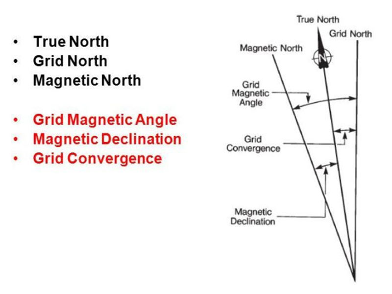
Where the main confusion comes from is the naming of the angles between True and Magnetic North and Grid and Magnetic North. More specifically over the definition of the term Magnetic Variation (Declination). According to some reputable sources, Magnetic Variation is the horizontal angle between Magnetic North and Grid North.
However, according to Ordnance Survey and the British Geological Association, Magnetic Variation (Declination) is the angle between Magnetic North and True North. The angle between Magnetic North and Grid North is the Grid Magnetic Angle (GMA) and it is this angle that needs to be applied when converting between Magnetic and Grid bearings.
As navigators we are primarily interested in Grid North and Magnetic North and the important angle is the Grid Magnetic Angle. On OS Landranger maps, this is shown diagrammatically in the middle of the North margin and mentioned in the Legend. On OS Explorer maps, the GMA is detailed in the Legend.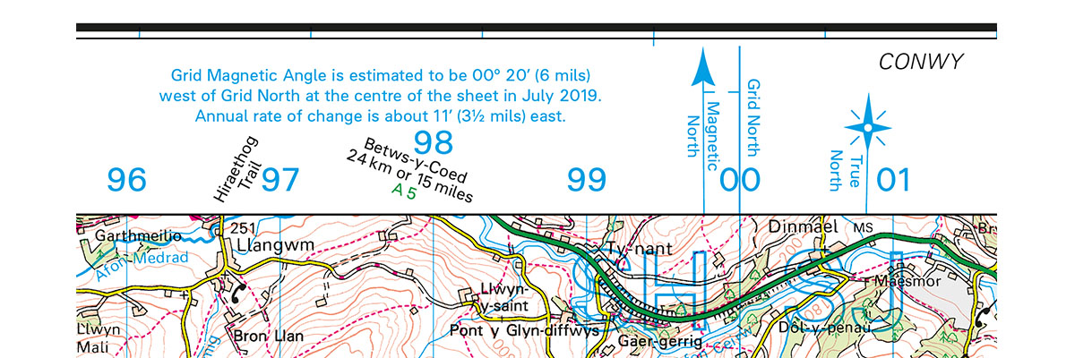
However, because the magnetic north is constantly moving, albeit very slowly, the GMA given for each map is correct only at the time of printing. The magnetic data shown on Ordnance Survey maps are supplied by the British Geological Survey (BGS). The BGS website includes a tool which will calculate the angle between grid north (British National Grid) and magnetic north at a given location from either coordinates or post code
For more information see the BGS Magnetic angle calculator.
How does that translate to the map and compass?
Remember the phrase “from grid to mag add & from mag to grid get rid”.
So you have taken a bearing on the map (grid) and want to use it on a compass (mag) we add the GMA. Taken a bearing with your compass (mag) and want to put it on the map (grid) we subtract the GMA.
Did you know…
For the first time in Great Britain since the 1660s, magnetic north moved from being to the west of grid north to the east. The change started in the very south west corner of Britain, currently affects the areas to the west of the line on our map, and will slowly progress across the whole country over the next 12 to 13 years. Find out more here.