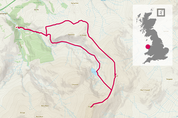
Tackling one of Wales’ 15 big peaks with views across Snowdonia, Anglesey and Liverpool Bay from the Foel Fras trig pillar.
SH 662 720
The route starts from either the Aber Falls car park, or from the small car park mentioned in leg 2. When you arrive here, there’s only limited pay and display parking on the road, but a large car park can be found by crossing the bridge and turning right. For those using public transport, there are plenty of buses that pass through the village from Bangor or Conwy. There’s a café in the village, which is always busy at peak periods. A good sign, but plan accordingly if you’re passing thorough on a sunny weekend! Toilets are available at the Aber Falls car park.
From the car parking on the lane, cross the bridge and follow the tarmacked lane uphill for 1.5km. This is a bit of a pull, but take heart that this is actually the steepest part of the walk and you’ll have got it out of the way at the start!
1.5 km
You’ll reach a small car park at the top of the lane, which is an alternative starting point, but you’ll be lucky to find room on a fine day. From here, cross through the main gate onto the grassy track beyond. This is National Trust land, and a sign denotes it. Turn left on the track, which then turns sharply right after 400m.
This is the old Roman Road, and this area of upland is steeped in history. It’s unfortunate that our recent contribution to this is the pylons that scar the landscape. The good news is that these cables should all be buried in the near future. Follow this track steadily for another 1.8km where there’s a convenient finger post pointing right to the track that leads to the summit of Drum.


3.8 km
Follow the track right, which is wide and steady all the way to the summit of Drum. The views start to open out as you reach the ridge, especially down to Cwm Anafon and Llyn Anafon in the next valley which will be the descent route.
From the summit of drum, the track peters out as it crosses the boggy col of Bwlch y Gwryd, but even in the wettest weather this shouldn’t pose a problem to cross. Continue across the bwlch, and onwards initially along the fence, which is replaced by the wall, all the way to the summit. Depending on the wind direction, you can cross the stile and walk on either side of the wall, with the far side having the least clear path but I’ve found the going generally easier. The path on the near side can be more slippery in the wet.
9.3 km


The summit of Foel Fras is easily identified by the trig point, which has a small and snug summit shelter nearby. It is usual for the wall to be used as a shelter of some sort, but you may find that the wind direction is parallel to the wall!
Views are across the northern section of Snowdonia, Anglesey and Liverpool Bay. The Isle of Man can often be spotted, and quite often you’ll find your phone connecting to the Isle of Man mobile network.
From here, you can continue on to Carnedd Llewelyn, but ensure that you can cope with the additional 8km this dog leg adds to the route.
Descend the way you came, back to Bwlch y Gwryd. You can return the way you came if you wish, or you can head on down the valley to Llyn Anafon. This route is wet in places, and there’s barely a path, but head for the lake and you should be fine. It’s only a kilometre, and even if the going is a little slow, it still saves time from returning down via Drum.


11.75 km
Once you arrive at Llyn Anafon, there’s an excellent track that descends without incident to the top of the lane from leg 2 where you can follow the lane back to the start. But there’s no need to rush, with Llyn Anafon usually being sheltered and a good spot to finish off any supplies. The minor summits of Yr Orsedd and Foel Ganol above the cwm can catch the evening light spectacularly, with a burst of green and purple contrasting with the drab uplands.
16.95 km SH 662 719
17 km / 11 miles