Haresfield Beacon in the Cotswolds gives glorious views over the River Severn all the way to the Black Mountains in Wales, This walking route offers a profusion of wildlife and historic sites.
SO 833 086
Start in the National Trust car park at Shortwood (SO 833 086). There’s an honesty box with a £2 donation suggested.
From the car park, go through the gap in the wall beside the entrance to enter Standish Wood. These woods are recorded in documents dating from 1297.
Several tracks head off from this point – take the left-hand one straight ahead, staying on the level and following the black acorn symbols of the Cotswold Way markers. If you do take a wrong path (or just want to wander!), it isn’t a problem so long as you eventually end up at the southern end of the woods.
On the day I visited, a cuckoo was calling through the woods and the ground was covered in bluebells, wood anemones, wood spurge, dog’s mercury and violets. Although predominantly a beech wood, the wood is also home to mature ash and other limestone-loving trees such as whitebeam, spindle and aspen. Conifers include Scots pine and larch, which attract cone-feeding birds such as Siskins, tits and Goldcrests, and there is a good understorey of hawthorn, holly and field maple. In the summer you may be lucky enough to find yellow bird’s-nest and bird’s-nest orchids. In the autumn fungi such as edible boletus and bracket fungi such as giant polypore make for a great fungus foray.
After 1 mile (1.6km) cross a track (known as the ‘Robbers’ Road’) and stay on the path. Look for an overgrown elongated mound on either side of the path (SO 827 071). This 200m-long Iron Age cross dyke is believed to have been constructed as a boundary marker.
After a few metres more look to your right for two small overgrown Bronze Age round barrows (marked as ‘Tumuli’ on the map). When one of these was excavated they found a cist with cremated remains and a Middle Bronze Age plano-convex flint knife, which is now in Gloucester City Museum.
Follow the wide path for a further 400m to reach a Neolithic long barrow about 4m high and 55m in length (SO 825 069). Although it is also overgrown, from the top of the barrow you will get a better sense of the scale of the monument. The horned entrance at the north-eastern end led directly to a single burial chamber which contained human remains, pottery and three flint flakes.
SO 825 069 – 2.5 km
Rejoin the Cotswold Way and turn left, following it for 400m, and passing a wildflower meadow on the left with lovely views east over the Stroud Valleys. Arriving at Ash Lane car park (SO 824066), you will be rewarded with wonderful views south and west over the River Severn.
Turn sharp right now and take the stone track downhill. Just after ‘Jackdaw Quarry’ turn right past a green metal gate and follow the track for 400m until it divides. Bear left down the steep stony track to emerge from the woods, leaving National Trust land.
There is a choice of footpaths from here – I followed the little shady one to the right of the two gates, which curved gently downhill to Standish Park Farm, from where I followed the lane for 500m – but you could equally take either of the other marked public footpaths that lead across fields, so long as you end up at Tudor House Farm (SO 817078).
Turn into the drive of Tudor House Farm for 30m and cross the stile on the left-hand fence (marked ‘public footpath’). Head towards a second stile near the left end of the fence at the top of the first field. Cross this stile and head steeply uphill to a third stile near the first crest of the hill.
Cross the stile and follow a vague path across the field past an old solitary oak. A fourth stile leads back onto National Trust land. Here you can wander at will again – either taking the direct route uphill or meandering to the right and finding a gentler approach to the top. As I ascended the limestone grassland, skylarks sang, the gorse was in full flower and I spotted several Small Tortoiseshell butterflies and numerous bright yellow male Brimstones. In the summer the meadows are full of ox-eye daisies, yellow rattle, vetch, buttercups and cinquefoil and orchids abound.
SO 817 080 – 4.9 km
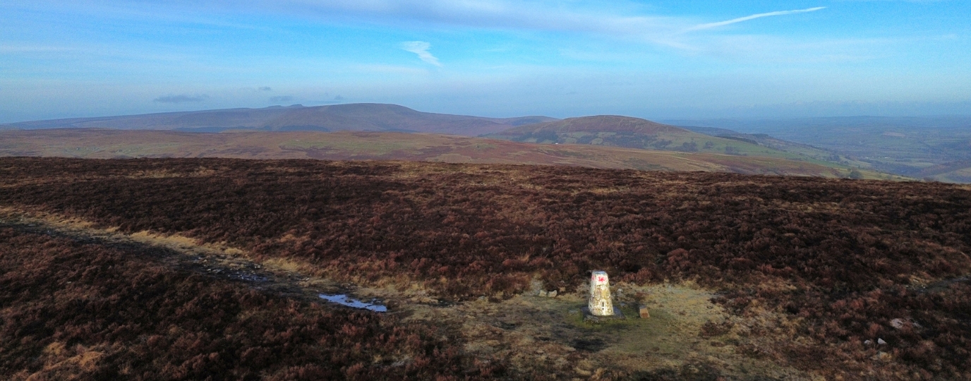
Here’s what you came for! The trig pillar itself is at SO 82037 08877, on top of a spur at the edge of the Cotswold escarpment. Built of local stone, it is adorned with two Cotswold Way markers, as the trail passes the spot. Haresfield Beacon is rated as one of the outstanding features of the 102-mile Cotswold Way.
From the Beacon you can look back at the way you have come through woods and farmland and then enjoy spectacular views of the Severn Vale to the Forest of Dean and the Brecon Beacons beyond. If the weather is clear you will be able to see the Severn Crossing.
From the trig pillar follow the narrow footpath heading north-east and through a gate to the site of a Bronze Age long barrow and the recently cleared ramparts of Ring Hill, an Iron Age hill fort. The Romans had a large camp here, and in the 19th century 3000 Roman coins were found. From the ramparts of the hill fort there are views towards May Hill, Gloucester and the Malvern Hills.
Return to the path, which leads back to the road and the small Beacon car park.
SO 820 089 – 5.9 km
Here, turn right down steps, following the Cotswold Way markers along the lightly wooded southern slope of Bunker’s Bank. On reaching level grassland, stay on the Cotswold Way and bear almost due south for 400m to reach the topographical lookout point (SO 828 084), which has fine views to complement those from the Beacon itself.
This 3-dimensional map of the district has direction arrows to all the points visible on a clear day.
From the topograph, take the broad path north-east to return to the car park, where you may be able to buy an ice-cream – an excellent way to round off a wonderful walk!
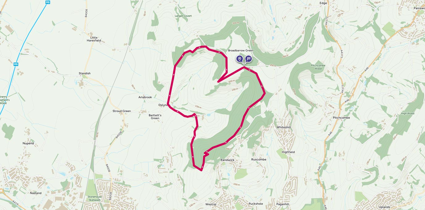
7.74 km SO 833 086
7.74 km / 5 miles