Night navigation across open moorland can be enormous fun and very rewarding, but it is not something to be undertaken lightly. You should be confident with your navigation skills in daylight before heading out.
SX 648 787
If you are going to try navigating in the dark, we would recommend getting some specialist training. Dartmoor makes for particularly interesting night navigation because although it doesn’t have some of the big features of our mountain regions, its previous inhabitants have left some fascinating (and sometimes scary) features. Please note: Sheep, ponies and stone crosses all look twice as big in the dark.
To its regular walkers, Dartmoor is a game of two halves. We have the South Moor – gentler hills and more of signs of habitation and then there is the North Moor – steeper, wilder, and generally more lonely. You don’t let a team of kids loose on the North Moor until you are sure that their navigation is up to it. Let’s face it; anywhere that has an area called “Killer Valley” has to have a bit of a danger factor to it.
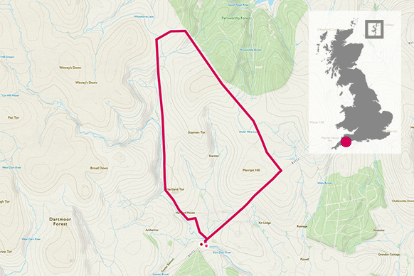
One afternoon in February, the Two Blondes set off for one of our favourite afternoon “into the dark” walks. We started at Postbridge and strode North (well we picked our way through the mud for quite a while first.) As we climbed, the mud eased a bit and we found ourselves at Hartland Tor – a nice tor in a lovely spot with views down over the East Dart valley. We spent some time around there looking for a navigation point or two and then continued north.


5.1 km
Our next goal was “Grey Wethers” a pair of Bronze Age stone circles, and we aimed to get there as it got dimpsy (dusk), have our picnic and walk back in the dark (you don’t have to be Blonde to do this stuff, but it helps). Grey Wethers is set in a wild and desolate spot in the shadows of Sittaford Tor and it was a struggle to get there across the water logged moor. There was a lot of tussock balancing – a skill you have to develop quickly if you want to get off track on Dartmoor.
As the sun set, and we approached the stones, both of us fell into a rather strange mood. Dartmoor is a mysterious place; it would be a very poor imagination that didn’t start murmuring at the sight of circles of dark, neatly placed stones appearing on the ridge of a very lonely hill. I think the precarious nature of our situation hit us both at that moment. It had taken us two hours to walk in because the moor was so waterlogged and we were two girls out alone on the North Moor with about half an hour of torch free map reading left. We didn’t feel inclined to stop for sandwiches as planned.

I was in charge of navigation, as this was the final training opportunity for my WGL night navigation reassessment (passed later that week) I elected for a different route back to the car. This was a risky strategy as the terrain could have turned out to be even worse; but the new route did mean that we could follow the edge of Fernworthy Forest South for most of the way. Neither of us particularly wanted to be near the forest in the dark. What looks like a friendly sheltered patch in the daylight, appears much more forbidding as darkness falls; and as we cut across to the forest the trees became bigger, darker and quite fierce looking.
There was a big stream gully across our route, and we decided to cross it before it got too steep, about 250m away from the forest. It was at this stream crossing point that we agreed to put our head torches on. Deciding exactly when to do this can be tricky; because as soon as your torch is on the world around you becomes darker and you lose the depth of vision that you previously had. It was the right decision however, as the stream, although small, was deep and surrounded by a lot of wobbly surfaces. We were so relieved to be across that we stopped and ate our sandwiches on the far side.
6.8 km


I am not sure whether it was the calories from the sandwiches, or the fact that it was now dark, but our nerves calmed at this point. We agreed in a Two Blondes unspoken way that we would keep the same distance from the forest edge and walked on a parallel bearing until we reached a wall. This took some time but it was peaceful. Apart from the ponies, we had the moor to ourselves. For the first time ever; I used the stars to navigate (set a bearing, see which star is in the right direction and follow it).
I am pleased to say that it wasn’t “the second star on the right” because otherwise we might have had to walk “straight on ‘til morning”! Blonde Navigation Fact: As the earth moves, so do the positions of most of the stars in the sky. If you choose to use them for navigation purposes, you need to recheck your bearing every fifteen minutes.
As the earth moves, so do the positions of most of the stars in the sky. If you choose to use them for navigation purposes, you need to recheck your bearing every fifteen minutes.The Two Blondes
9.2 km
Once at the wall it was a case of some careful micro navigation to pinpoint our exact spot and then another bearing across some more wobbly terrain to the road. Which, as roads often seem to do in the dark, crept up on us. I don’t often blow my own trumpet (although I do carry a whistle) but this practice in particular gave me bags more confidence about my ability to get a group down off the moors in the dark should the need ever arise.
11.2 km SX 648 787
11.2 km / 7 miles


