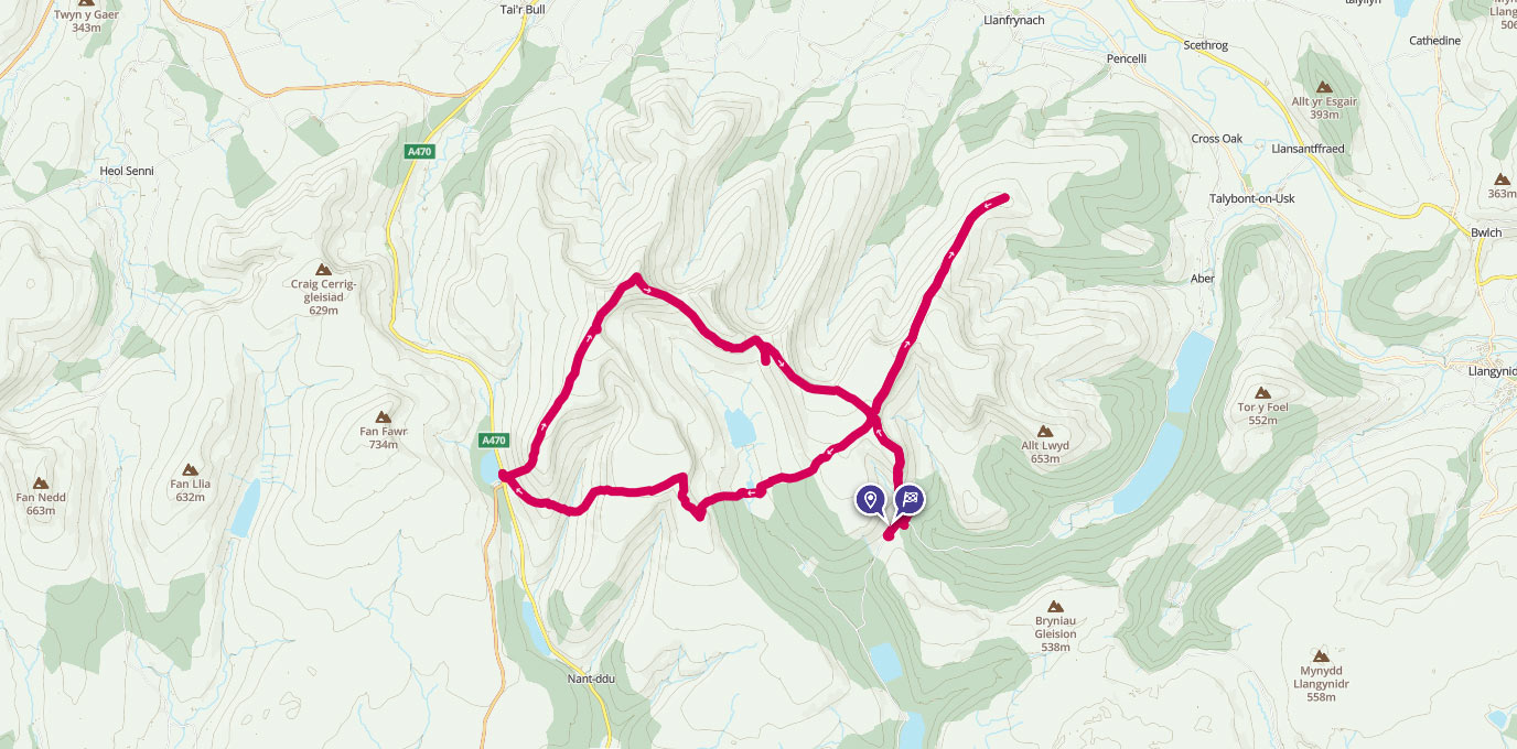
A serious challenge, trig 642 is, despite its modest height, quite possibly one of the most demanding trig pillars to bag, if you stay true to the way it would be reached if you were on Special Forces ‘Selection’.
SO 052 172
0500: Huddled together surveying our maps we decided on our route selection – that was our first error. It wasn’t so much the route selection we chose, but more so the route we didn’t take, which would cost us significant time. None the wiser though and happy with our route we set off, however it wasn’t long before we were climbing hard over boggy ground.
Following our bearing we quickly stumbled into even worse conditions and had the maps out looking for relief and features. Stupidly we hadn’t paced that first leg so had no real idea how far we had travelled, and in the pitch black and no real features to navigate from we were guessing on our location. We decided on a new bearing to get us out of the water and climbed to higher ground before setting back on the bearing we thought we should be taking. By the time we’d got ourselves back on track (and found fresh footprints), daylight had replaced the bleakness and darkness of the early hours.
SO 072 227
Once at RV1 (Bryn) nav to the the next grid was straightforward. It was just the terrain we had to get ourselves over to haul up to Trig 642 and RV2. We approached from Lower Neuadd Reservoir, and as we stood at the base of the climb looking up, you don’t fully realise what you’re taking on. The first rise is tough enough but as it plateaus you’re stood there, looking at another rise the same height that you’ve just got yourself up. The decision is then, do you plod like you’re done, or push hard? It’s the latter of course and by the time you hit the top you’re blowing hard, but boy is it worth it.
SO 022 176
For me for two reasons, the views from up there are stunning even with the clag in, you can see enough to marvel at the beauty all around, but more importantly for me, I decided before I set off, that at Trig 642 I would place my little tribute to Lloydy. When I got up there and checked in, it felt like the right place. There wasn’t much ceremony, I just muttered a few words to myself and just hoped that he’d heard them.
By this point we had no real idea how far we’d gone, or how far we had to go, we just knew we had to keep going and next up was the prospect of “VW Valley”. Grid to RV3 (Beacons Reservoir) given and route selection done we knew at some point we’d have no choice but straight down and straight up. If anything it’s those steep downs that are tougher on the body than the ups, the knees and feet take an absolute pounding trying to ensure you don’t make like a cheese wheel and forward roll into the valley floor. We reached the valley floor relatively unscathed other than a little protest in the lower limbs and started to climb back out the valley. The sickener came though as we plateaued and looked across to our right and saw people clambering up the adjacent slope.
SN 989 183
On reaching RV3 heads dropped a little as we were informed “you’re going up there”, up the slope we’d noticed people clambering up as we’d got ourselves out of “VW Valley”.
That climb out of RV3 was hideous, a slow ascent, that used almost every ounce of grit left. The climb in certain places meant grabbing hold of anything you could to pull yourself along. Grabbing hold of thistles became the norm until the fingers were numb, and after what felt like a long 45 mins, I was standing on top of the slope taking a well-earned breather.
SO 012 216
Pushing towards the next RV, I must admit, I knew it wouldn’t be long before we needed to get the head torches back out, so stretched it out a bit, by the time we got to the climb up towards RV4 (Pen Y Fan) I was feeling pretty decent other than the bergen wearing itself permanently into my traps. All assembled at the RV we were given our next and what turned out to be our final grid (our start point).
Descending the Fan, by now there was no light, it was pitch black, and with at least another hour to go, trusting the compass became paramount. We had a couple of little wobbles but with great map reading and trusting our bearing we hit the path that signified we were on the last stretch home. A red strobe close to the start point signalled endex and the day done!
We were done, a long day but successful day in the hills!
31 km SO 052 172
31 km / 19 miles