Walk Through Time With Britain’s Stone Circles
Everyone knows about Stonehenge, but it’s far from the only ancient stone circle in the British landscape. From the windswept moors of Orkney to the quiet fields of Cornwall, these prehistoric monuments are scattered across the country, each with its own story, setting, and sense of mystery. Dramatically placed within their surroundings, they offer a powerful link to the past, standing for thousands of years through weather, time, and change.
How many stone circles or ‘henges’ are there in the UK?
There is no definitive number but according to Wikipedia there are over 1300 stone circle in the UK. No one knows exactly what stone circles were used for, but most agree it was probably for rituals or ceremonies. Many stone circles seem to be aligned with the sun or moon to create shadows, making people believe they may have acted as huge sun dials. Some stone circles were used as cemeteries as archaeologists have found human remains around or inside the circles.
Whether you’re pausing mid-hike, snapping a dramatic photograph or planning a contemplative visit, these circles invite reflection and exploration. We’ve gathered a selection of some of Britain’s most evocative stone circles for you to explore on your next adventure through the countryside.
If these ancient stone circles spark your curiosity, take a look at our 10 Roman sites in Britain for more fascinating historical locations to visit. And if you’d like more ancient history, be sure to check out our Ancient Britain map. It’s filled with historic sites across the country, highlighting the rich tapestry of history woven into every corner of the landscape. Whether you’re planning a walk or simply exploring from home, it’s a great way to uncover the stories behind Britain’s most atmospheric places.
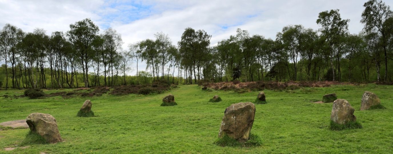
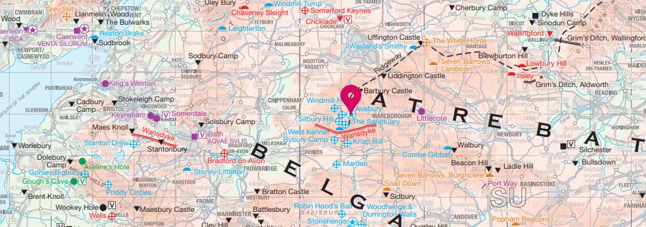
Avebury
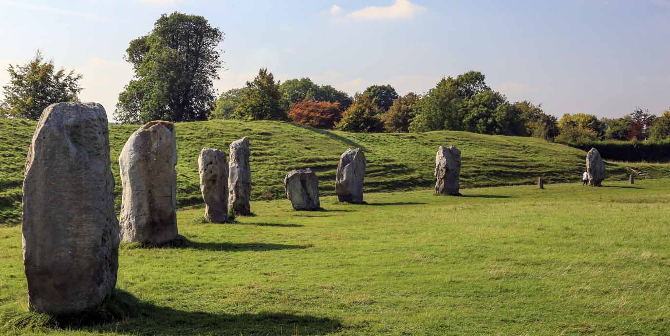
Age: c.2850 BC – 2200 BC (Neolithic)
Number of stones: 30 (originally around 100)
Diameter of circle: Approximately 330 metres
Stone type: Sarsen stone
Set within the rolling chalk downs of Wiltshire, Avebury offers one of the most immersive encounters with Britain’s prehistoric landscape. As the largest stone circle in Europe, it comprises of an outer henge, an enormous circular ditch and bank, and three rings of standing sarsen stones, some weighing over 60 tonnes. Unlike its more famous neighbour, Stonehenge, Avebury surrounds a living village, allowing visitors to wander freely among the stones and experience their scale and presence up close.
The wider landscape is rich with ancient landmarks that make for a rewarding day on foot. Silbury Hill, the tallest man-made prehistoric mound in Europe, looms nearby, while West Kennet Long Barrow offers a quiet, atmospheric detour into Neolithic burial rites. Well-marked walking paths link these sites, winding through open fields, hedgerows, and gentle ridges.
Callanish Stones
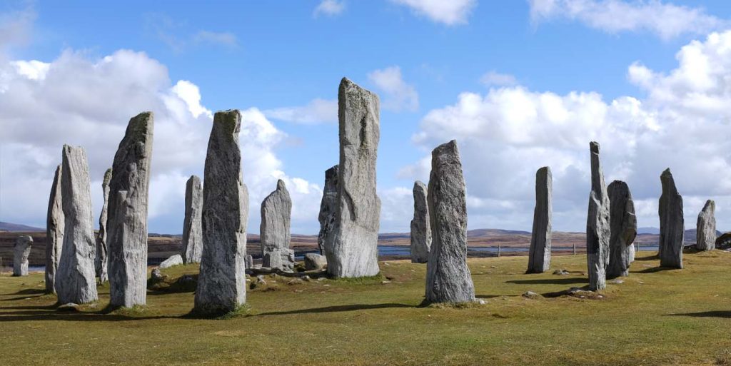
Age: c. 2900 – 2600 BC (Neolithic)
Number of stones: 13 in the central circle, around 50 across the site
Diameter of circle: Approximately 13 metres
Type of stone: Lewisian gneiss
Set against the dramatic backdrop of the Isle of Lewis, the Callanish Stones, or Calanias Stones, rise from the peat-rich moorland. Surrounded by sweeping views of lochs, hills, and open skies, the stones are thought to have served ceremonial or astronomical purposes, possibly aligned with lunar cycles. Their layout is striking, with not just a circle, but a cruciform arrangement with avenues and outliers that add to the sense of deliberate design.
The location itself invites exploration. With open access and a network of nearby trails, it’s ideal for a gentle wander from nearby Callanish, pausing to reflect, or simply soaking in the raw beauty of the Hebridean wilderness.
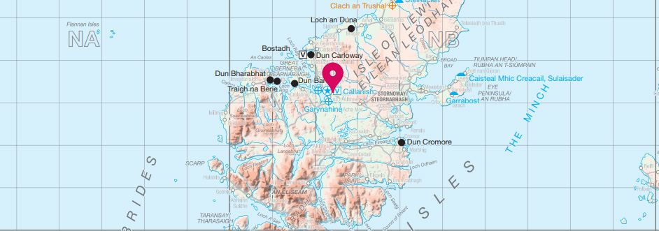
Boscawen-Ûn

Age: c.2500 – 1500 BC (Neolithic – Bronze Age)
Number of stones: 19
Diameter of circle: 25m and 21m (elliptical rather than circular)
Type of stone: Granite, and one quartz
Hidden among the hedgerows and farmland of west Cornwall, Boscawen-Ûn’s stones stand quietly in a grassy clearing. A single, taller stone stands out within the circle, possibly aligned with astronomical events, adding a sense of purpose to the circle. Although modest in scale, the site’s peaceful setting and gentle character make it a rewarding stop for walkers seeking a quieter kind of heritage experience.
Surrounded by low-lying fields, patches of gorse, and ancient trackways, Boscawen-Ûn feels like part of a wider sacred landscape. It’s slightly off the beaten path, but easily reached via local trails, making it ideal for those combining light hiking with a touch of prehistoric intrigue.
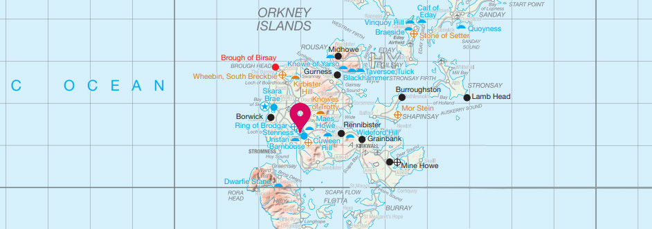
Stones of Stenness
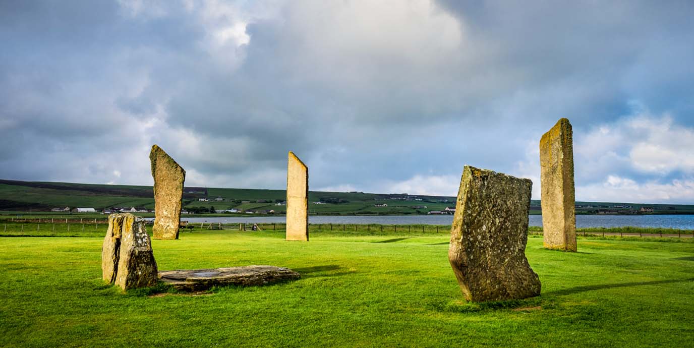
Age: c.3100–2900 BC (Neolithic)
Number of stones: 4 (originally 12)
Diameter of circle: Approximately 32 metres (elliptical rather than circular)
Type of stone: Orkney sandstone
Set on a low rise between two lochs, Loch of Harray and Loch of Stenness, in Orkney, the Stones of Stenness stand tall and slender, forming a wide circle that commands the surrounding landscape. Exposed to the elements, the site offers sweeping views across open farmland and distant hills, creating a powerful sense of place. Although only a few stones remain upright today, their height and sharp silhouettes make them a striking presence against the sky.
Dating back to as early as 3100 BCE, this is one of the oldest known stone circles in Britain. Its ceremonial or ritual significance is closely tied to nearby monuments like the Ring of Brodgar and Maeshowe, forming part of Orkney’s Heart of Neolithic Orkney World Heritage Site. Easily accessible via walking paths, the site is a rewarding stop on a longer route through this ancient landscape.

EXPLORE THE
OS Shop
We are with you every step of the way. Shop our trusted walking and hiking maps and guidebooks so you can explore the outdoors with confidence.
Go to the shopSwinside Stone Circle
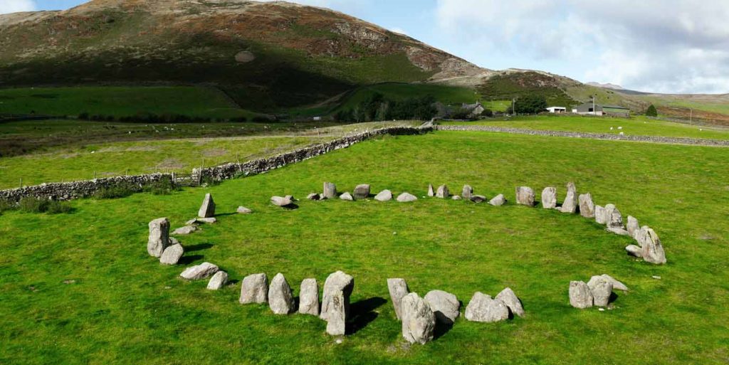
Age: c.2400-1000 BC (Neolithic – Bronze Age)
Number of stones: 55 (originally around 60)
Diameter of circle: Approximately 28.7 metres
Type of stone: Porphyritic slate
Nestled on the quiet slopes of Black Combe in Cumbria, Swinside, or Sunkenkirk, offers a striking glimpse into Britain’s ancient past. It’s southeast-facing entrance aligns with the midwinter sunrise, hinting at ceremonial or astronomical significance. Although its original purpose is unknown for certain, local legend adds a touch of folklore: the stones were said to be part of a church construction, until the Devil intervened and sank them into the earth.
A mile-long walk from the nearest road leads visitors through open farmland and gently rising terrain, with views that stretch across the Lake District. It’s accessible via public footpaths, and its remote location ensures a beautiful walk and a peaceful experience, far from the crowds.
Moel Tŷ Uchaf
Age: c.2300 – 800 BC (Bronze Age)
Number of stones: 43 (original number unknown)
Diameter of circle: Approximately 12 metres
Type of stone: Unrecorded, but a local stone transported by glaciers
High in the hills of Denbighshire, North Wales, and not far from Eryri National Park, Moel Tŷ Uchaf sits on a grassy ridge offering wide, open views across valleys and moorland. The roughly circular arrangement of stones encloses a central area that may once have held a burial or ceremonial feature, such as a cairn. Modest in scale compared to some of Britain’s stone circles, it carries a quiet dignity, its simplicity matched by the simple beauty of its surroundings.
The site is remote and peaceful, reached by footpaths that wind through farmland and open countryside. Its elevated position gives walkers a clear sense of connection to the wider landscape, with sweeping vistas. For those seeking solitude, archaeology, and a touch of wild Welsh charm, Moel Tŷ Uchaf offers a rewarding breather in the hills

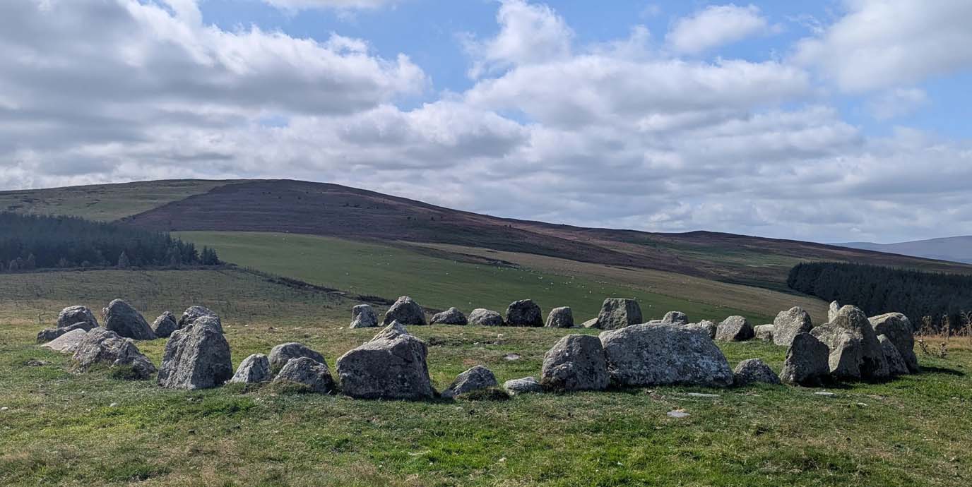
King’s Men Stone Circle
Age: c.2500 BC (Neolithic)
Number of stones: 70 to 77 stones – although it is famously said to be impossible to count them and get the same number twice (originally around105)
Diameter of circle: Approximately 33 metres
Type of stone: Oolitic limestone
Set on the edge of the Cotswolds near the Oxfordshire–Warwickshire border, the King’s Men stone circle, part of the Rollright Stones, offers a quiet encounter with ancient history. The circle is a compact ring of weathered stones, with gently rolling views across open fields and scattered woodland. It’s an easy and peaceful stop for walkers exploring the area’s rural footpaths, with the kind of understated charm that invites a pause.
Thought to have served ceremonial or social functions, the site is part of a trio of monuments that add layers of intrigue to the landscape. Just a short walk away, the Whispering Knights, an early Neolithic burial chamber, and the solitary King Stone stand as silent companions to the circle. Together, they form a walkable route from nearby Salford, ideal for those seeking a blend of folklore, history, and the soft beauty of the English countryside.
EXPLORE THE
OS Shop
We are with you every step of the way. Shop our trusted walking and hiking maps and guidebooks so you can explore the outdoors with confidence.
Go to the shopRing of Brodgar

Age: c.2600 – 2400 BC (Neolithic)
Number of stones: 27 (originally around 60)
Diameter of circle: Approximately 104 metres
Type of stone: Orkney sandstone
Set on a narrow strip of land between two lochs in Orkney, the Ring of Brodgar rises from the heath, surrounded by water, sky, and distant hills. As one of the largest stone circles in Britain, the Ring of Brodgar likely held ceremonial or astronomical significance, though its exact purpose remains a mystery. Its scale and symmetry are impressive, even in partial ruin, and the surrounding landscape is rich with archaeological treasures.
Part of the Heart of Neolithic Orkney UNESCO World Heritage Site, the circle is a magnet for walkers and outdoor explorers drawn to both history and solitude. Well-marked walking routes link the Ring of Brodgar with nearby sites like the Stones of Stenness and Maeshowe, offering a unique journey through time and terrain.
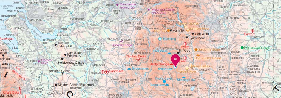
Arbor Low
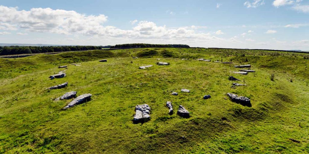
Age: c.2400-1000BC (Neolithic – Bronze Age)
Number of stones: Around 50 (originally around 41-43, but are now fragmented)
Diameter of circle: Approximately 37-42 metres (estimated)
Type of stone: Limestone
Located high on the limestone uplands of Derbyshire, Arbor Low lies within a deep circular ditch, surrounded by open fields and the signature drystone walls of the Peak District. The landscape here is windswept and gently rolling, offering wide views and a quiet, rural atmosphere. Unlike many stone circles, Arbor Low’s stones lie flat on the ground, although they may once have stood, giving the site a distinctive character.
Nearby burial mounds and the connected Gib Hill barrow hint at the area’s long-standing ceremonial significance. The site is just a short walk from nearby lanes, making it an easy detour for hikers and history-minded ramblers.
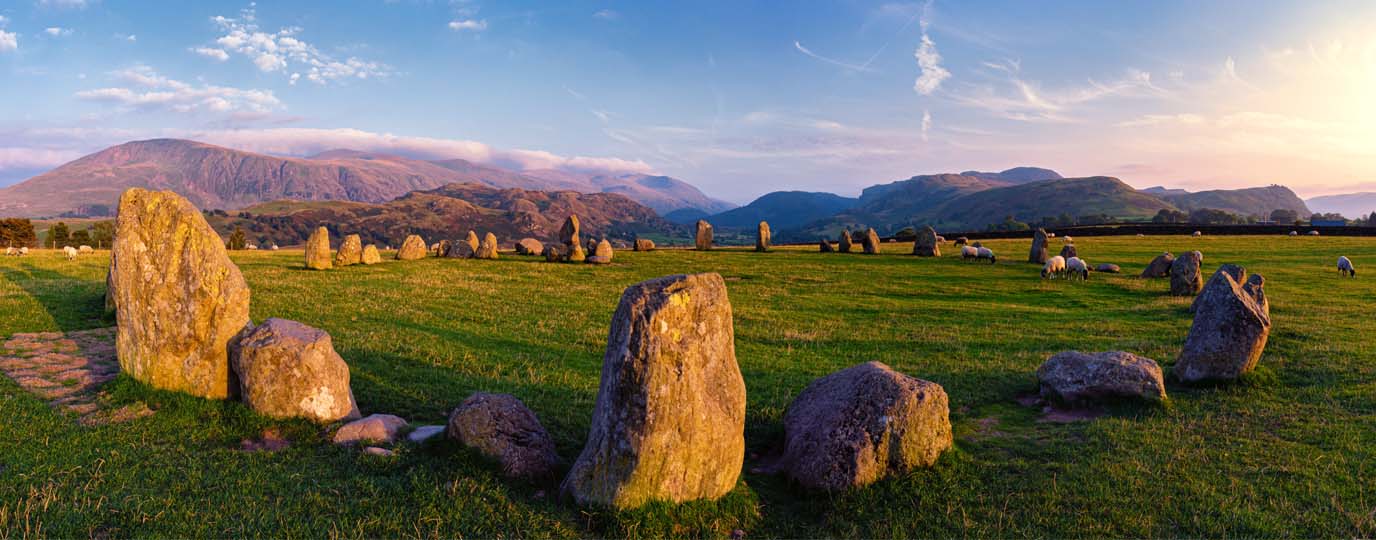
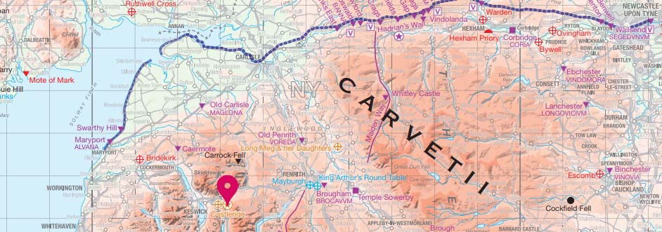
Castlerigg Stone Circle
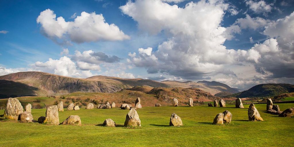
Age: c.3000 BC (Neolithic)
Number of stones: 38 (originally 42)
Diameter of circle: Approximately 30 metres
Type of stone: Volcanic rock from the Borrowdale Volcanic Group
High on a plateau above Keswick in the Lake District, Castlerigg stone circle offers a breath-taking blend of ancient mystery and dramatic scenery. Surrounded by the rugged silhouettes of Skiddaw, Blencathra, and the central fells, this Neolithic monument is one of the oldest stone circles in Britain. Although its original purpose remains uncertain, possibly ritual or ceremonial as many stone circles might be, its elevated position suggests a deliberate connection to the surrounding peaks and open sky.
Unlike some stone circles nestled in valleys, Castlerigg stands exposed, offering panoramic views that shift with the light and weather. The site is easily reached via a short walk from Keswick, making it perfect for a morning stroll or a reflective sunset hike. With open access, visitors can wander among the stones, sit quietly on the grass, or simply take in the sweeping vistas.
Looking for more of Britain’s history?
If these stone circles have whet your appetite for history, take a look at these vintage maps on the OS shop. While they might not be thousands of years old, we have over 470 available covering the whole of Great Britain from 130 years ago. Not only do they make for a great gift for a history or map lover, but they also look fantastic framed on a wall. You can even compare them side by side with modern OS Maps to see what changes have occurred over time.