Your walking route planner
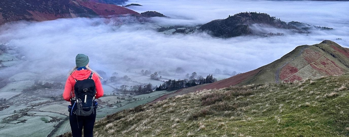
Don’t just follow others – planning your own walking route can be a rewarding experience, helping you discover new places or set yourself challenges. Jonathan from the OS Team outlines how you can get started and find new walking routes with the help of a walking route planner. If you’re looking at heading into the mountains you may find our hiking for beginners article useful too.
It’s easy to find a walking route – friends, guidebooks or our own OS Maps route database are just a few of the options – but planning and completing your own route gives you more flexibility and a great sense of achievement. Here’s my quick guide to planning a route in five easy steps.
1. Pick your map
The best maps for planning walking routes in Britain’s countryside are the OS Explorer 1:25 000 scale maps as these show the most detail. If you are walking on a National Trail or other larger trail you can also use the 1: 50 000 scale OS Landranger mapping.
If you are planning an urban route a street map can work well, although many show little detail if you are crossing green spaces. For your own safety, don’t try to use larger scale maps designed for driving, as these do not show enough off-road features. You will find the same lack of detail with many online maps using Google Maps data, as few footpaths are shown.
The Best Walking Route Planner App
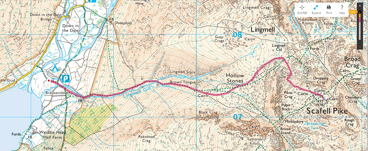
Planning a walking route in OS Maps
For this article I’m going to use the OS Maps online system to plan the route, but you can also use a pencil with a paper map.

EXPLORE THE
OS Shop
We are with you every step of the way. Shop our trusted walking and hiking maps and guidebooks so you can explore the outdoors with confidence.
Go to the shop2. Decide on your route start and length
Now you have your walking route planner either downloaded to your phone or on your laptop or a paper map you can start planning your walking route!
You probably already have a start point in mind. Your home is probably the first choice, but a free car park is often a good start point too. Other people will pick a train or bus station so they can get to their route in an environmentally friendly way. Ending at a pub or café is always a good idea!
Choosing an area with more footpaths will generally allow you to plan a circular route, which is more interesting than a straight out and back. If you want to plan a one way route, either find a place where you can leave a vehicle at both ends or look for start and end points on a bus route or near a train station.
Your average walking speed will be around 5km/h (3.1mph). This assumes level ground with easy paths and does not allow for stiles, scrambles, streams or any of the other things you might encounter.
If you are in hills or mountains, you can also use Naismith’s Rule. For each 100m of elevation gain, add 10 minutes to your time.
Plan your walking route length based on the ability of your whole group and the time you have available. Don’t forget to add on time for breaks for refreshments or photos. The larger the group the slower you are likely to travel, so allow extra time for this too – big groups of 20 or more will generally travel at about 3km/h!
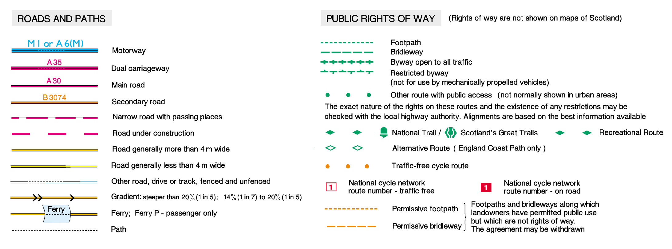
Roads and paths plus public rights of way in OS Maps
3. Planning your walking route
The simplest routes follow waymarked paths, such as National Trails marked with green diamonds. Green dotted lines on OS maps show trails with rights of way, while black dotted lines show trails that may or may not be a right of way.
In England and Wales, you are generally limited to walking only on the rights of way, except in selected areas such as National Parks. In Scotland, you are allowed to walk almost anywhere under the right to roam act.
Don’t be afraid to plot at least some of the route on the quieter ‘B’ and ‘C’ class roads (shown in orange and yellow) if this can help you join two footpaths together. Many of these are quiet and the tarmac surface allows you to make good time.
Draw or plot your route on the map. If you are using OS Maps online or the OS Maps app, you will get a running total of the distance as you plot the route, but if you are using a paper map you will need to use a ruler or piece of string to estimate the length.
Remember that the distance on the ground will be slightly longer than on the map. You can get a fairly accurate idea of length by plotting your route to follow the path, but there will always be a margin for error where you have to detour round mud or find a safe crossing for a stream.
Walking Route Planner – Top Tip!
When planning walking routes I like to ensure I include varied terrain wherever possible. It keeps the routes interesting if you can mix woodlands, inland and coastal/waterway paths. If you are looking for a good view, keep an eye out for the viewpoint maker on the map.
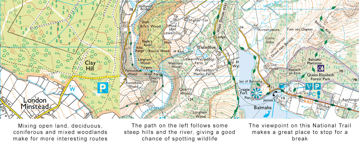
Things to look out for when planning a walk in OS Maps
4. Check for danger points
There’s more to it than just finding the best walking routes planner app! The safety of your route is going to be very dependent on the weather. If possible, check the weather the day before so you can amend or plan your route accordingly.
Wind and rain
What may be a breeze and light rain can become dangerous winds and sleet or snow at higher altitudes. Make sure your waterproof gear is up to the task, and if you can take paths that avoid the peaks.
The Met Office has this useful mountain forecast to help you enjoy the outside safely.
Wet weather
In persistent wet weather (often called ‘summer’ here in the UK) lower lying areas can become very muddy or impassable. Larger maintained paths are usually fine, but smaller ones is wet areas are often best avoided.
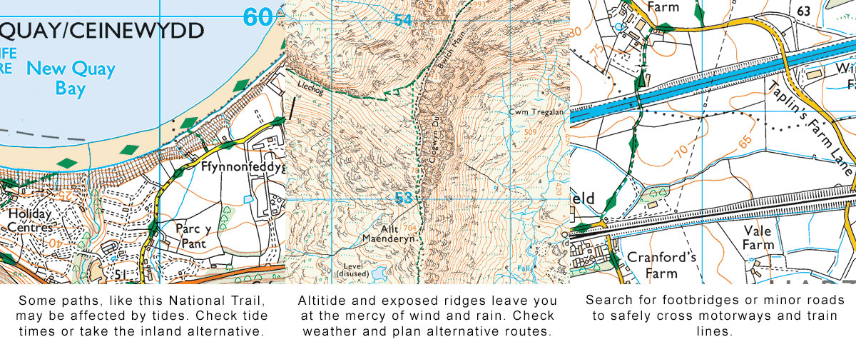
Small streams on a map can become rivers too fast to ford, even a couple of days after rain, so pay attention to small blue lines, and look for ‘FB’ (for footbridge), rather than ‘Ford’ or nothing.
Roads and train lines
You may have to cross roads. While out of town ‘B’ and ‘C’ roads may not have pavements, they are usually relatively quiet with grass verges. ‘A’ roads and dual carriageways are much more dangerous, and should be avoided unless they can be crossed at recognised crossing points.
It’s illegal to walk on motorways, even to cross them. You will find footpaths that cross motorways using dedicated bridges.
Many rural train lines use level crossings. Pay attention to any warning signs and remember trains may be moving faster than they appear at first.
Coastal dangers
The biggest danger on coastal paths is the tide. Some paths will disappear under the waves at high tide, so you may find yourself stranded or trapped against cliffs.
Check the local tide tables as you are planning your route. The Met Office also has this useful beach forecast to help you enjoy the outside safely.
Steep slopes and altitude – understanding contour lines
You may have your walking routes planner app downloaded or your map spread out with your routes pencilled in but do you understand the contours?
On OS maps contour lines indicate a change in elevation. The closer they are together, the steeper the slope will be – see this video for help understanding contours. Going at right angles to the contours means a steep climb or descent, while a path that follows the contour lines means a drop to one or both sides.
If the slope is also marked with small round circles it means there is loose rock or ‘scree’.
While a path over these areas will generally be possible, make sure every member of your group is capable of taking it on. If a steep slope is combined with poor weather it can go from tricky to hazardous very quickly.
Getting up to the top of a hill or mountain is a great goal for a walk, but be aware that temperature drops and wind speed increases as you gain altitude. A t-shirt weather day in the valley will probably need a fleece on nearby hills, while cooler weather will require better insulation, hats and gloves.
Getting up and down hills also uses considerably more energy than walking on the flat. Be aware of the abilities of your group, and remember that having a big climb near the end of a route can be a killer on the legs. You might want to investingate using hiking poles – read our hiking poles guide which has everything you need to know about picking a pair of hiking poles.
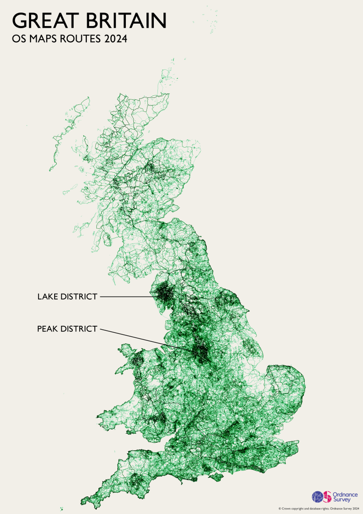
Just some of the routes created in OS Maps
Planning a walk in winter weather
Living in a temperate climate (despite our complaints) we tend to not get many extremes of weather. Even in winter it’s not that cold, especially if you are out walking.
However, this can change massively in our mountains. Heavy snowfall, ice, low temperatures and wind chill means that if you are venturing out anywhere above 300m you need to be prepared and equipped. This will mean high-performance clothing, crampons and an ice axe are likely to be required, along with the skills to use them.
Hitting a mountain peak in winter can be a hugely rewarding experience – but make sure you are ready.
Daylight
Again, you may be feeling confident having downloaded your walking route planner app but you must consider timing. While night navigation can be an interesting challenge, it definitely needs good map reading skills. Check local sunrise and sunset times – if you have travelled to the north of Scotland in winter they can be surprisingly short days.
If you are planning a route that will take longer than the daylight hours, you are generally much better off starting in the dark and finishing in the light. Errors made in the dark are easier to remedy near the start of your walk. Combining fatigue with darkness at the end makes mistakes more likely.
Escape routes and emergency contacts
Make sure you have escape routes in mind, especially on longer routes or high altitude walks. These are fast routes back to a safe point, such as a road or houses. Ideally you avoid any difficult terrain such as steep slopes or climbs. You can also plan an alternative route that allows you to continue, but avoids exposed peaks.
Should the weather turn against you or someone gets injured your escape route is the quickest route back to safety. As you near each escape route compare your position to your schedule – if you are too far behind, or any of the group are struggling then it may be an idea to take it.
In critical situations, volunteer Mountain Rescue teams cover many of the most popular areas. You should only call them if absolutely necessary, such as in the case of injury. Ensure you have at least one phone with power at all times. To contact them, dial 999 and ask for Mountain Rescue. You will need to give them the location – OS Maps location sharing, a GPS device lat/long or a traditional grid reference taken from a paper map are all options.
Equipment
In addition to your map and walking routes planner app you will need to think about essential walking gear. Equipment will vary a lot depending on the distance, route and season. A gentle stroll with a pub at the end may require nothing but a phone for emergencies.
For anything over 30 minutes you should plan to at least take some water. Most of the time you need to be prepared for changeable weather, so thin layers and a packable waterproof jacket are a good idea.
Longer walks will need more water plus food. A torch is a good idea in case you return later than planned, as is a spare mobile or a power source for your main phone. If you are heading to more remote areas an emergency blanket or bivvy bag and first aid kit are sensible additions – see our First Aid & Safety products.
For an overnight stay there’s a lot more to think about, but you need to take enough to be reasonably comfortable and safe, but keep the weight you are carrying to a minimum.
You should also always take a printed map and a compass – whether it’s a full paper map or a print from OS Maps. Even if you use a phone or GPS device as your main navigation system, keep the paper version in your bag for emergencies.
Just following route notes or a smaller map extract can get you round a planned route, but will not help if you stray off the route or need to cut it short.
Some features to look out for in OS Maps
If you’re planning your first adventure hiking in the mountains and hills of the UK then read our Hiking For Beginners Guide which has some additional info related to walking on high ground.
5. Get going!
Now you’ve planned and prepared, it’s time to #GetOutside!
Do a final weather check, and if you are going on a route of any distance leave a copy of your planned route with family, friends or your accommodation provider, together with the expected time of return – in OS Maps you can use the ‘share route’ function to share a copy of your planned route easily. You can also export the GPX file if you wanted to follow the route on a GPS device.
Do a final gear check on what to take walking and what to wear too. Don’t forget to lock the front door!
If you’re not sure about using a walking routes planner on your phone, watch this quick and easy guide.