For me a proper outdoor adventure always involves a tent or bivvy bag. See, I’m a wild camping addict – from mountain summits to hidden caves, under boulders or snuggled in bothies – I like to take my sleeping bag and head to the wildest places I can find. And it doesn’t come much wilder than Knoydart.
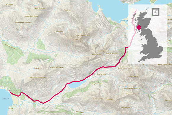
Located between the two lochs of Nevis and Hourn is this peninsula, a jutting mountainous cluster of contour lines stretching into the sea. Sure it has a road. Just the one – 11km of tarmac that sits alone, not connected to rest of UK road network. And at the end of that road, sits the most remote pub in Britain called The Old Forge (www.theoldforge.co.uk). For this walk the main question is: How far would you walk for a pint? Because to enjoy that first sip of a post-walk ale is quite an adventure. You’ll need to start first in Mallaig where you’ll jump on a boat to drop you at Barrisdale Bay. From there it’s a long walk to the pub – and the campsite on Long Beach – but one you’ll never forget…
NG 873 059
Taking the ferry from Mallaig to Barrisdale (pre-booking essential – see www.knoydartferry.com and westernislescruises.co.uk) is the perfect introduction the peninsula – with mountains soaring either side and dolphins leaping alongside your boat it feels like you’re headed somewhere very special indeed. Depending on the tide you’ll land next to some rocks that will require scrambling over to reach the beach. Once at the beach, without forgetting to take at least a couple of minutes to admire the views of this incredibly jaw-droppingly beautiful slice of wild sand, head to the land where you pick up the path heading south-west.
0.25 km
You’ll pass a sign telling you that Barisdale (where there is a campsite and bunkhouse) is just 10 minutes walk away. Follow the path past the tents and buildings heading towards a copse of woodland with a white building ahead. As you get closer take the path as it turns to your right and, ignoring the fork on your left, via a bridge, cross the steam and continue on the path as it ascends steadily uphill. Continue on, climbing up to the col of two mountains. The cairn at the top is a fantastic place to stop for bite to eat.


5.0 km
It’s now a downhill stroll skirting the beautiful waters of Loch an Dubh-Lochain. Soon you’ll spy the tiny hill with the cross adorning its summit – a memorial erected by former landowner Lord Brocket to honour his family. Continue heading towards it on the well-defined path then climb uphill slightly into some trees, continue on and through the wooden gate.
14.5 km
Take the lower path as it winds down alongside the wall and soon joins the tarmac road at the bottom. For one of the best campsites in the UK turn left, passing houses and camping barn/hostel, and emerge on the sea shore where, for the bargain price of £4 you can pitch your tent, with a compost toilet and fresh water on tap – with money-can’t-buy views over to Rum and Skye. If you’re dying for your pint – or your pre-booked mealtime is fast approaching – then turn right and the road will take you all the way to the pub for a well-deserved celebratory pint!


All images © Phoebe Smith
16.0 km NG 766 001
16 km / 10 miles