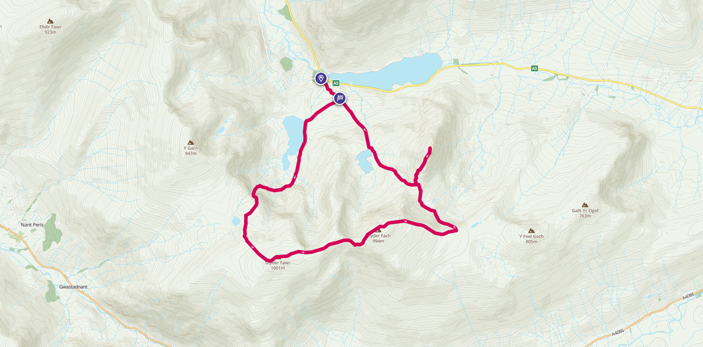
Where else can you go where you can bag 3 of the huge Welsh 3,000 foot peaks, visit places called The Canon, Cantilever Stone, Devils Kitchen or the magnificently titled Castle of the Wind, enjoy an ending worthy of any Hollywood blockbuster and all this and never be further than 1.5 miles away from the car park.
But really, the best bit of this day walk is whilst the other, slightly taller (but a lot less fun) peak just across the valley creaks under the weight of all the day-trippers making the pilgrimage to the Snowdon summit coffee shop, this part of the national park is deserted in comparison. Shame, but not really!
SH 64879, 60417
The walk starts off in the visitor centre car park at the western end of Llyn (Lake) Ogwen and conveniently has a refreshment shop and toilets (make use of these as there aren’t any at the top of this one). You’ve already been treated to hint of what’s to come as you headed west along the A5 passing the fin shaped profile of Tryfan but there’s plenty to come before that.
Like all good walks this starts off from the car park with a gentle flat walk which does just enough to warm up the muscles.
Head south east towards the massif before taking a right hand turn towards Llyn Idwal where the path now starts to gain some height.
Skirt around the edge of the lake towards the foot of the imposing Devils Kitchen which rises like a cliff face from the end of the lake and start to climb the grade 1 scramble.


Aim for the gap in the wall (where legend says the rising steam warned homebound sailors that land was near and also lent it its name) but don’t enter.
Instead, swing around to the left in front of the rock face and soon you’re up onto a grassy platform which feels a little out of place following that climb.
Turn left again now with the impressive peak of Y Garn behind you and climb the path that zig zags it’s way through the scree and up onto the Glyderau plateau.
Straight away this becomes a weird, eerie place to be especially on a day when visibility is pretty much zero. Glyder Fawr (1,001 masl) is the first peak to tick off and is crowned with a formation of claw-like rocks menacingly poised to grab you at any moment. Not that we could tell as we could barely see it.
With conditions like this navigation is key as there’s no real path and coupled with a sheer drop on the left (which on a clearer day would give a lovely view back to the car park).
But stick to the path which hugs the edge of the plaeau and soon you’re arriving at the second peak Glyder Fach (994 masl).
But before you get there, make sure you make the diversion to the Cantilever Stone, a flat slab of rock that appears to have been delicately placed just to appease the selfie generation.


After the summit of Glyder Fach you will get the first glimpse of the real star of the day; Tryfan. Tryfan (918masl) is smaller than the other 2 peaks but it’s a proper, conical shaped mountain. There’s no walking up here, it’s a grade 1 scramble the whole way.
With ropes and helmets required on the eastern face and a chance to test your wits on The Canon stone on the northern face, this mini mountain has it all, but first you need to get there. There is a direct route from here to the foot of Tryfan but this a severe scramble down.
Instead take the path that swings away to the right (eastwards) which descends relatively gently for 200 metres before coming to a crossroads.
Turn left and the path brings you back towards Tryfan with the steep cliffs of Glyder Fach to your left. As you do you will most probably start to notice more people coming the other way as this is the more usual way around to do this walk. But this way round, the whole walk has built up to this final peak.
The path starts to climb again and soon you’re at the foot of Tryfan. The southern face is the most accessible route up but it is still a scramble and a lanky 6 foot frame is a real benefit when hauling yourself up over the huge blocks that make up the surface of this peak.
The satisfying climb is not all that this has to offer though. Once at the top there’s another chance to test your metal with the leap from Adam to Eve; 2 erect monolithic stones that are just begging to be tried. Complete this jump safely and you’re promised the freedom of Tryfan!

You can choose to avoid Tryfan altogether by heading straight down from the Glyder Plateau but that would be
like leaving the cinema before the end of the film. Once you’re finished at the summit, safely climb back down the same way and re-join the well-established path heading north-west back to the car park and reflect on a good days adventuring.
SD 90001, 62683
10.5 km / 7 mi


