The English Lake District is blessed with some of the finest scenery in the United Kingdom. Its fell tops, Lakes and Tarns have inspired many an artist and poets work! The many walkways and National Park paths there cater for all abilities to enjoy these beautiful surroundings at any time of the year. I am fortunate enough to live within an hour or so of the Lake District, so it has become my playground of choice.
Like many others I have often been tempted by the imposing fells and their craggy summits. The Scafell’s, Helvellyn, Skiddaw and Blencathra to name a few. Yes I have climbed all of these, and enjoyed their majestic views. But what am I missing in the many valleys and forests down below when I am stood on a summit? There is an abundance of beautiful scenery and wildlife down there that I am missing out on as I eat my sandwich, drink my tea, and catch my breath up there. Today I wanted it to be the valley below that took my breath away, not the climb!
NY 085 153


So today I met up with Annette an instagram friend who was also keen to tackle the long walk along Ennerdale Valley. We met at 10am at Bleach Green car park where parking is free ( I love this route already).
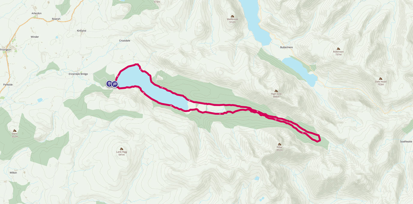
The information board here next to the main gate shows a map of the different walks you can do around Ennerdale Water and beyond. Handily these are colour coded depending on length, all are low level though. Distance varies from 2 miles to 8 miles. The walk we were doing today is not on the information board as it is the full length of the valley and back which is 15 miles approx! The beauty of this walk is there are many footbridges across the River Liza, so once past Ennerdale Water you can make this as long or short as you are comfortable with.


After a quick introduction for Annette and I, and a curious sniff for Rocky and Tasha (our dogs), we were on our way.
I decided we would get more enjoyment out of the walk if we tackled it in an anti clockwise direction, there was no real logic to this, it just felt appropriate on the day!
The section of footpath here as you walk along the lakeside on Anglers Crag is the only real rocky section of the walk, and it does rise slightly as you follow the path away from the waters edge. Once around the Crag it is then a straight walk along the well marked footpath to the end of the lake and the beginning of the plantations. Once you enter the Ling Mell plantations it is a well define track that you follow through the woods. Take time here to have a look at the many pretty streams and cascading waterfalls that run down into the river. They really are a beautiful sight.
Annette and I were in full stride now as we talked about our shared passion for the great outdoors, and the benefits it brings to your health and well being. The dogs seem to be enjoying themselves equally as they chased each other through the woods and streams, jumping in to the refreshing waters to cool down (as nice as that looked it is still too cold for humans! Or Me!) As you walk through the woodlands, every now and then you come to a clearing in the trees, and the huge mountains that encompass this valley would remind you of their part in this beautiful setting.
NY 122 138 4.25km


NY 175 131 10km
Pay particular attention to Pillar and Pillar rock as you pass. You cant help but marvel at this aggressive looking but enticing array of rock. Pillar Rock is said to be the birthplace of Rock climbing in the UK, and it is easy to see what draws daredevils to its steep flanks (if only I didn’t have the dog with me). I jest of course, I prefer my feet firmly routed to the ground! As you continue on Easterly you then get your first view of the end of the valley in the shape of another lakeland giant, Great Gable (another climbers favourite).
We were soon out of the woods and heading towards Black Sail Hut (YHA) for a rest and a brew. Ennerdale valley is undergoing a transformation to return it to its `Wildest` state and therefore you will never find traffic here. The hut can only be accessed on foot or mountain bike. As we had hardly seen anyone else so far on our walk we expected the hut to be empty. As we approached it became evident that this was not the case. There was a good 20 or 30 walkers/cyclists there all with the same idea, to rest and enjoy a brew in the warm afternoon sun.


NY 195 123 12.5km
We chatted to many of them and exchanged our adventures stories from the day so far. What is clear to me on my walks is that when you talk to people, you’ll never see someone who is not enjoying what they are doing. We all have that same sparkle in our eyes and speak passionately about our days. I do love that! We could have sat here for the remainder of the day and basked in the surroundings, but alas we were only half way through our walk. We packed away our flasks, rounded up the dogs and headed on our way for the return leg.
We were soon back in the woods on the Northern side of the Liza river, and the views back down the valley were just as amazing as on the way in. We were making good time on the return leg, largely due to a well maintained flat path all the way through the plantation.


Just a precautionary note, if you do take your dog on this route be careful of the sheep around the Latterbarrow woods area. They spook the dogs when they appear from nowhere and vice versa!
It wasn’t too long before we could see the glistening light on Ennerdale Water again. We stopped for a quick break and for the dogs to cool off. Taking this opportunity to take lots more photos of the lake and the views around us. To summarise, this has to go down as one of my favourite walks in the Lake District. The valley is uniquely wild and home to hundreds of species, although we only saw sheep and swans today, it is also home to the native red squirrel (maybe next time i’ll see one?) The vast amount of Oak and Birch trees here are a perfect environment for the thriving wildlife. It is also a nice place for us Humans to visit to de-stress!
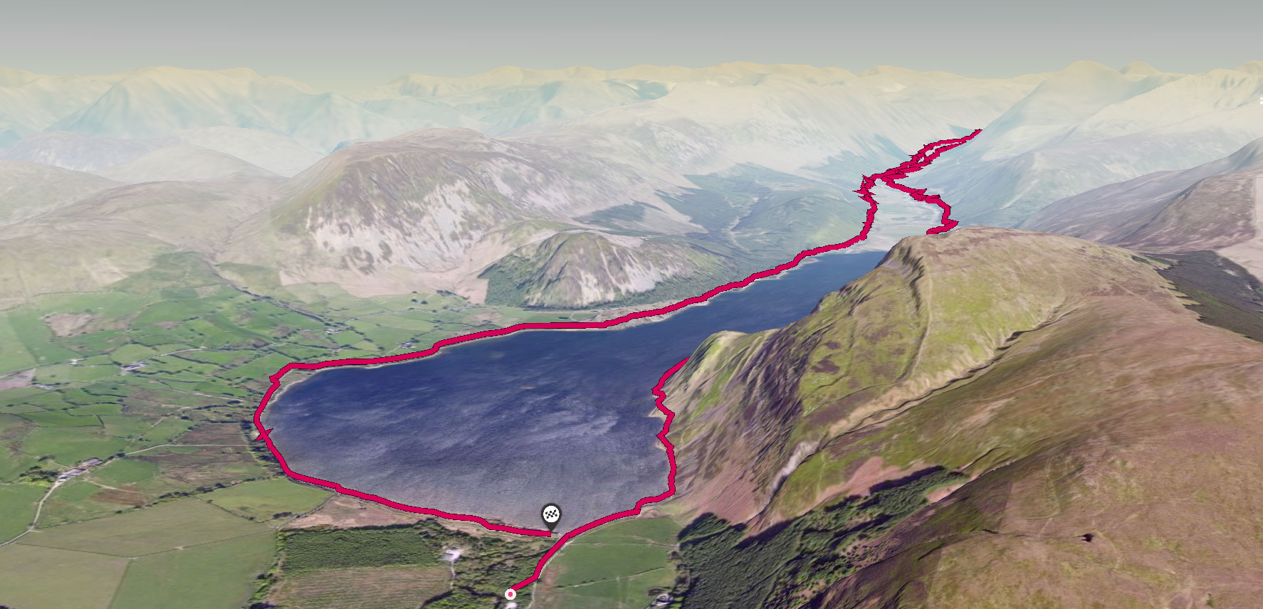
The route in OS Maps 3D view
So the next time you are looking for a low level high adventure walk on your OL4 map, Look no further than Ennerdale Valley!!
24.5km NY 085 153
25 km / 16 miles
