This is a great family walk to do on a sunny afternoon as it has plenty of suitable stopping off points for refreshments along the way. There is lots to see and, even better, fish and chips at the end!
NO 492 000
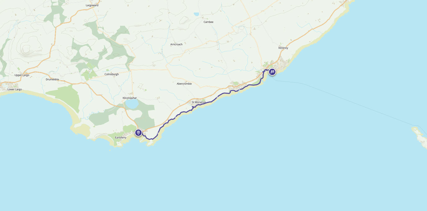
We did this linear walk by parking in Elie and catching the bus back from Anstruther Harbour. The buses are regular and quick.
Start the walk from Elie High Street and follow the signs for the Fife Coastal Path down towards the harbour. On reaching the harbour we had to follow the high tide path as we couldn’t get onto the beach. This is signposted and takes you around the back of some houses before turning right back onto the Coastal Path.
The first bit of the walk takes you along the dunes and beach of Elie East Links, my young boys enjoyed searching for shells, and looking in rock pools.
After 1km, leave the beach and head back up to the path. Follow this well-trodden route, past some interesting sandstone rock formations up to the 15th century remains of Ardross Castle:
www.stravaiging.com/history/castle/ardross-castle.
Then, follow the path for just over 1km as it wanders along the top of the cliffs towards the second castle on this walk, Newark Castle-
www.undiscoveredscotland.co.uk/stmonans/newarkcastle.
There is also a restored dovecot near this castle to have a look at.
After a break to look around these buildings, we walked a further 1km along the path towards St. Monans. The low tide route is well worth doing as it edges along the side of St. Monans Church:
www.undiscoveredscotland.co.uk/stmonans/parishchurch.
5.0 km – NO 525 016


After paddling through the burn near the church, head up the hill following the signs for the Coastal Path. Walk round the harbour, which still has a fishing fleet and smoker, towards the windmill and salt pans at the edge of the village:
www.undiscoveredscotland.co.uk/stmonans/windmill/index.html.
On the day we did the walk the windmill was open as the local Volunteer Coast Watch team were on duty. We were allowed to look inside and my sons had a great time listening to all the ships in the Forth over their radios, and trying on some of the kit used by the volunteers.
www.coastwatch-irvine.co.uk/coastwatch.html
After a further 1.5km you reach the pretty village of Pittenweem. By this time we were in need of refreshments and, handily, there is a choice of pubs and cafes in Pittenweem. You can find options on the harbour front or further up the hill in the village. (Pittenweem hosts the open doors Arts Festival each August, where locals open their houses up to local artists to use as galleries to sell their art – see pittenweemartsfestival.co.uk. If you are there at the right time, it is well worth a visit).
After a cuppa, we re-joined the Coastal Path to Anstruther. This edges around a golf course so look out for low flying balls! Past the golf course, follow the signs and take a brief diversion from the coast into the town of Anstruther before emerging back out at the harbour and a multitude of fish and chip options including the Award winning favourite of the Royal family, the Anstruther Fish Bar.
If you have time and energy, there is plenty to do in Anstruther: visit the RNLI Station to see their boats (an inshore and Mersey class), investigate the Fife Fisheries Museum, or even take a boat trip over to the Isle of May- www.nnr-scotland.org.uk/isle-of-may.
The bus stop back to Elie is located by the RNLI station.
- Bus information: www.travelinescotland.com
- Fife Coastal Path information: fifecoastalpath.co.uk
10.2 km No 569 034
10.2 km / 6 miles